Old Kasilof Landing SRS Site Development
Project Description
The Division of Parks and Outdoor Recreation (DPOR) has received capital improvement funds to develop a public drift boat takeout on the lower Kasilof River in an effort to address increasing demand for this type of facility on the popular drift-only fishing portion of the river. Phase 1 of the project was completed in 2015 and included the acquisition of two adjoining parcels, property investigation, site planning, and preliminary permitting. In preparation for the development of the site, Phase 2 was completed in 2017 to remove unnecessary debris and undesirable facilities. Phase 3 will be a construction contract to develop the site in preparation to open for public use.
Background
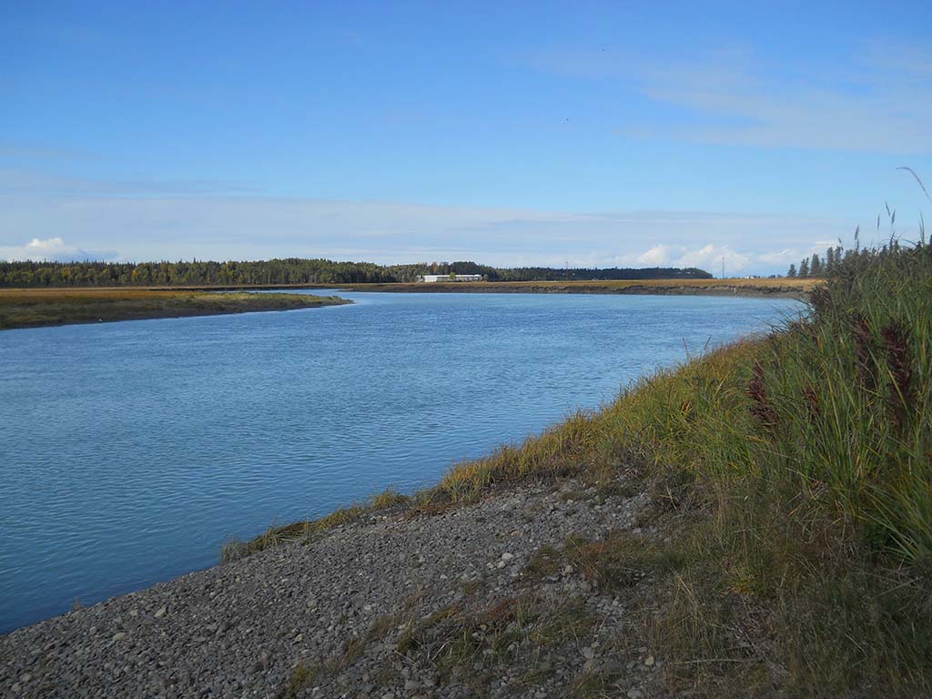
The Kasilof River State Recreation Site boat launch, located at mile 109.4 on the Sterling Highway, provides a put-in and ramp, but there is no public takeout available on the lower portion of the river. The Division has received comments from the public since the late 1980s regarding the lack of a public retrieval on the river. Concerns intensified in 2007 when a popular private boat retrieval site announced that they would be closing the following year.
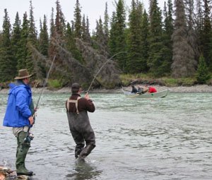
In 2008, DPOR and the Alaska Department of Fish & Game funded a feasibility study on two parcels of land identified for analysis as potential launch/retrieval alternatives. These sites were evaluated, through a public process, for their hydrologic qualities; constructability; potential for site contamination; cultural resources; capitol and operations and maintenance costs; and permit constraints. Although neither site proved to have all the necessary elements for a retrieval facility, some important factors were gleaned from the process about the public need. At the time of the study, the public opposed creating a power boat launch near the drift boat fishery indicating that it would cause user conflicts and change the culture of boating and fishing on the river.
Project Planning
As part of the first phase of the planning process, a short questionnaire was distributed to learn more about where a retrieval site should be located, what criteria should be established for evaluating sites and finally what type of facilities you would like to see in conjunction with the retrieval site. The Division learned a great deal from the responses (available below) to the questionnaire that then helped inform the creation of criteria that the Division used to evaluate potential sites along the river. The criteria are organized in two parts. The first part lists a series of factors that need to be considered for each potential property and the second part is used to score potential properties on the various factors.
In 2011, a public workshop was held in Kasilof to present the draft criteria and solicit feedback on how it could be improved. After receiving additional feedback during the comment period, the evaluation criteria were finalized. Later that same year, a multi-disciplinary team of representatives from DNR conducted a field investigation of the eight available parcels and scored them using the evaluation criteria and score sheets along with the available data for each site. The data included cultural resource site information, photos, aerial photography, topographic maps, flood & soil data, community density & tax assessment maps and survey/status plats. By mid-January, the parcel selection criteria score sheets were tabulated. Below you will find the final criteria, a map showing all the sites that were evaluated and a list of the parcels evaluated in ranked order.
Project Update
In 2015, DPOR acquired the top two ranked parcels identified in the Ranked Parcel List. A planning process was conducted to consider users' needs and the physical constraints of the river as well as to gather public feedback on the project. The process led to the development of Site Plan Concept A, Site Plan Concept B, and Site Plan Concept C (available below). Those concepts were presented at two public meetings during the winter of 2016/2017: one in Kasilof and another in Anchorage. Feedback from those meetings resulted in narrowing down the concepts for advancement into the design phase of the project.
Work to demolish unneeded structures and environmental clean up work at the site began in 2017. In 2018 the Department of Environmental Conservation approved the environmental cleanup work. On-going sedimentation survey of the boat take-out area was initiated in 2019. A cultural resource survey was completed in 2020. Design and permitting was sufficiently completed in 2024.
Over the course of design, it came to light that the initial funding was insufficient to construct the final concept in its entirety. DPOR partnered with the National Park Service and secured federal funds from their Land and Water Conservation Fund (LWCF) program for full project build-out. The project is currently in construction.
Documents & Additional Information
Kasilof Boat Retrieval Project Questionnaire Results
Map 1- Lower Kasilof River
Parcel Evaluation Map
Ranked Parcel List
Site Plan Overview
Project Plans
Project Change Order No. 2
Public Comment Form
Frequently Asked Questions
Is the site design completed?
The site design is complete and is now under construction.
Is the engineering for the boat retrieval system finalized, evaluated, and approved?
The boat retrieval system is about 95% complete. The design is being finalized and permits being secured.
Are all bids in place for construction and operation?
The construction contract was awarded on June 24, 2024.
Is the construction budget finalized?
We have a construction budget established based on the engineer's estimate.
Is the operational budget finalized?
The operational budget increase has not yet been determined.
Is the continuing budget in place?
No.
Have all permits been secured?
All permits for the advertised scope have been secured. Permits for the boat retrieval system is in progress.
Is the sedimentation survey for the boat take out site completed?
Yes
Has the final design for the boat retrieval system been confirmed?
No.
Have operational details been determined and approved?
Details such as fees and potential hours of operations have not been finalized.
Are the plans solidified for this summer's work? Are contracts in place?
Construction of the project has begun.
Have the fish cleaning stations been removed from the site plans?
The fish cleaning tables have been omitted from the project scope at this time.
Is Regulation 11 AAC 20.914 (OKL is drift boat retrieval only) still in place?
Yes
Has the name of the site been officially changed to "Old Kasilof Landing Drift Boat Retrieval?"
Park has not considered changing the official name of the site.
What is the intent of the Old Kasilof Landing project?
To provide a much-needed public drift boat "take out" location on the Lower Kasilof River.
What facilities and amenities are included in this project?
The Old Kasilof Landing Boat Retrieval Facility will include:
• 47 truck-and-trailer stalls
• 12 passenger vehicle stalls
• Circulation trail to separate pedestrian and vehicle traffic for safety
• Vaulted toilets to help maintain sanitary conditions
• Orientation kiosk
• Interpretive program to highlight the site's features
• Group and day-use area
• Landscape mounds and privacy fence along property lines
• Paving to control airborne dust
• Gates, barrier rocks, site signage, and striping for access management
What are the hours of operation, season, and quiet hours of the facility?
Operational details are being worked on by regional staff. More information will be posted as the facility takes shape.
What is the retrieval system? What is the process for choosing the retrieval system?
The final design for the boat retrieval system has been developed by a consultant and is based on user/stakeholder input.
How will overflow parking on the road outside of the facility be addressed?
DPOR plans to post "no parking" signs on the property and entrance road areas, near the parking lot being constructed for the truck / boat trailer parking. DPOR Law Enforcement staff does not have authority to ticket vehicles parked outside of a park unit but does work closely with the local authorities to address additional concerns should this become an issue.
Construction Questions:
When will construction begin?
Construction began in July 2024.
What is the schedule and hours for construction?
Construction is scheduled to take place until early 2025. The hours of operation are based on contractor activities and may change over the course of construction.
Are there drainage or water quality concerns?
DPOR has no reason to believe there are water quality concerns currently. Construction activities will conform to a site-specific Stormwater Pollution Prevention Plan in accordance with the Alaska Department of Environmental Conservation's construction general permit.
Contact:
The resident engineer may be contacted for the latest construction information at:
Dalan Merriner, Project Engineer
(907) 748-7647
dalan.merriner@alaska.gov
January 10, 2023 Project Update meeting:
For more information, to get added to the project mailing list, or to comment, contact:
Kenai/Prince William Sound Area Superintendent
PO Box 1247
Soldotna, AK 99669
Phone: (907) 262-5581
Mission Statement
"The Division of Parks and Outdoor Recreation provides outdoor recreation opportunities and conserves and interprets natural, cultural, and historic resources for the use, enjoyment, and welfare of the people."