Parcel Detail
")
Parcel 499 - 16
Agricultural Auction
Region:
Northern
Ag Area: Nenana-Totchaket Subdivision, Phase 1B (Agricultural Lots)
Case File: ADL 422688
Brochure Pages PDF
Ag Area: Nenana-Totchaket Subdivision, Phase 1B (Agricultural Lots)
Case File: ADL 422688
Brochure Pages PDF
Acres: 125.18
Road Access
Lot: 4 & 5
Block: 5
Case File
Attention
Corporations, businesses, and non-Alaska residents ARE eligible to bid for parcels of agriculture land.
The sale of agricultural interest is the conveyance of the land estate and subject to conditions and covenants relating to agricultural use and development.
The required covenants are:
1. A perpetual covenant for the benefit of Alaska residents and running with the land that restricts of limits the use of the land for agricultural purposes; and
2. A perpetual covenant that permits the owner of the land, obtained under this contract, to subdivide and convey not more than four parcels of the land of not less than 40 acres each, subject to the restriction that a subdivided
parcel may not be further subdivided and further subject to the limitations established within AS 38.05.321(e).
Agricultural Purposes are defined in statute as:
1. The production, for commercial or personal use, of useful plants and animals;
2. The construction of: housing for landowners and farm laborers, improvements for animals, improvements that are reasonably required for or related to agricultural uses;
3. The use of gravel reasonably required or related to agricultural production on the parcel conveyed; and
4. Removal of and disposition of timber in order to bring agricultural land into use.
Agricultural Parcels may be subject to Preference Rights. All prospective bidders should familiarize themselves with the “Agricultural Preference Right” section of the auction brochure.
Location
Nenana-Totchaket Phase 1B is located within the DNR’s Northern Region, about 55 miles southwest of Fairbanks, approximately 10.5 miles west of Nenana. Phase 1B is
approximately 2.5 miles west of Phase 1A.
Meridian Township Range Section (MTRS): F004009W08
Access Details
From Parks Hwy, head west on 10th Ave, then northwest on Totchaket Rd. Continue west on Totchaket Rd, crossing the Nenana River bridge. The beginning of Phase 1B is
approximately 2.5 miles west of the intersection of Totchaket Rd and Moe’s Rd. It is
approximately 10.5 miles west of Parks Hwy.
Access to Parcels 13 & 14 is from Schade Ln. Parcels 10, 11, and 16 are accessed directly from Totchaket Rd. However, Parcels 11 and 16 are set back from the constructed roadbed. Parcel 11 is approximately 250 ft from the road, and Parcel 16 is approximately 350 ft from the road. Parcels 12 & 15 can be accessed from either road, though the parcels are closer to Schade Ln.
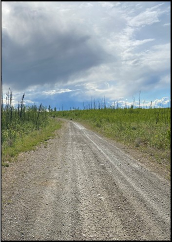
Schade Ln and Totchaket Rd are both unmaintained gravel roads.
Utilities
There is no municipal water supply or sewer system. Please see plat notes and the Sewer and Water section of this brochure for details. Electricity has not been extended to Phase 1B.
Local Government
This area is located in the Unorganized Borough and is subject to the state of Alaska
platting authority.
Fire
This area is in the Modified Fire Management Option. See the Wildland Fires and Burn
Permits section of this brochure for details.
Notes
These parcels may contain wetlands. Purchasers must obtain permits from the U.S. Army Corps of Engineers before developing any wetland areas.
Parcel 16 is comprised of two lots- Lots 4 & 5 of Block 5.
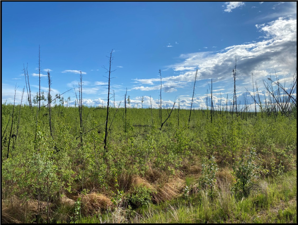
In 2009 the area was affected by the Minto Flats fire. All parcels were affected and are in the process of recovery.
Misc/Other
Area soils have been classified by the Natural Resource Conservation Service (NRSC) of the USDA within the following categories: Class 3, Class 4, Class 5, Class 6, and Class 7. Please see the Land Capability Classification Definitions section of this brochure for details.
Farmland classifications include cleared cropland, wooded cropland, Alaska Exempt
Wetlands, wetlands, and land not suitable for agriculture. Wooded land may be in a
natural state or regrown, but it is suitable for farming when cleared. Alaska Exempt
Wetlands (AEW) are soils with random ice pockets that make large contiguous areas
difficult to develop. However, once the native vegetation is cleared, the land may become
arable.
Restrictions
Easements affecting these parcels, as depicted on the plat, may include, but are not limited to, utility easements and section line easements. Information on restrictions, easements, reservations, and setbacks may be depicted on the plat, contained in the plat notes, or recorded separately. There is a 30ft wide public utility easement along all rights-of-way within the subdivision. Parcels 13 & 14 have a 50ft section line easement along the northern lot lines. Parcel 10 has a 50ft section line easement along the western lot line. Please see plat for details.
Survey and Appraisal
Nenana-Totchaket Subdivision, Phase 1B is survey ASLS 2021-17, located in Sections 4, 5, 6, 7, and 8, Township 4 South, Range 9 West, Fairbanks Meridian. The survey has been recorded as plat 2024-1 in the Nenana Recording District.
Right-of-way Status
Access within the area ranges from constructed gravel roads to brushed rights-of-way.
Totchaket Rd and Schade Ln are constructed gravel roads.
In 2025 the City of Nenana entered an agreement with AK DOT to maintain Totchaket Rd from the Parks Hwy to mile 6. This agreement is binding through October 2028. It is unknown if the agreement will be extended or the road will be maintained upon its expiration. Currently, Tochaket Rd is unmaintained beyond mile 6. All other developed roads within the project area are unmaintained. Property owners will be responsible for any winter plowing/ summer grading in these areas.
Agricultural Covenants
Nenana-Totchaket Phase 1B is classified for agricultural use. Please see the "Development Requirements & Agricultural Covenants" section of this brochure for details about Agricultural Land Sales.