Skip to content

Warning: JavaScript is disabled.
For full functionality and best experience on our site, it is necessary to enable JavaScript.
Here is instructions to enable JavaScript in your web browser

We use cookies to provide and improve our services. By using our site, you consent to cookies.
Alaska Department of Natural Resources
Division of Mining, Land and Water

Parcel Detail

Attention - Residency Requirements

Only Alaska residents may submit bids in the Sealed-Bid Auction.
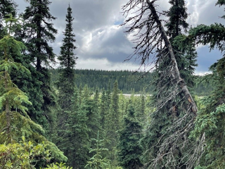
Parcel 497 - 1038

Region: Southwest
Subdivision: Big River Remote
Case File: ADL 216930
Brochure Pages PDF
Acres: 36.07 No Road Access Tract: A
Minimum Bid:
$35,600.00

Case File

Veteran Discount

The State of Alaska offers qualified Alaska resident veterans a once-in-a-lifetime discount on the purchase of state land.

Estimated Veteran Price: $26,700.00

This veteran's price is based on the minimum bid. When placing your bid, you will be bidding a non-discounted price. The actual discounted price based on your bid will be calculated using the method detailed in the brochure, if you qualify for the program and win the parcel.

Attention

There is a very dilapidated trapper’s cabin on this property as well as the remnants of an additional structure that has collapsed. There is trash and debris in and immediately around these structures. Small gasoline, kerosene, and propane cans/tanks, as well as an old car battery were observed on the property during the most recent field inspection. No other toxic material, waste, or hazards were observed during the field inspection. Please see the appraisal report for details. DNR MAKES NO WARRANTIES AS TO THE “NONEXISTENCE” OF CONTAMINATION NOT NOW IDENTIFIED. STATE RECORDS ARE NOT A WARRANTY AS TO ALL POTENTIAL CONTAMINATION. As a condition of sale, the apparent high bidder must sign an affidavit acknowledging the condition of the land and releasing the State from related liability due to the presence of potential hazards. This affidavit must be signed by all bidders and notarized. This affidavit must be received at DNR’s Anchorage or Fairbanks offices by the auction paperwork deadline of 4:00 p.m., Thursday, December 11, 2025. As with all parcels, DNR recommends prospective bidders personally inspect all parcels before placing a bid.

Location

The parcel is approximately 76 air miles southeast of McGrath, along the bank of the North Fork Big River.
Meridian Township Range Section (MTRS): S022N028W29

Access Details

Summer access to the parcel is via wheeled plane to area gravel bars or backcountry airstrips, then overland to parcel. Winter access is via ski plane. There is an airstrip on State-owned land to the southeast of the parcel, however it is separated from the parcel by a small braid of the river. This airstrip is not maintained by the State of Alaska or any government entity.

Utilities

There is no municipal water supply or sewer system. Please see plat notes and the Sewer and Water section of this brochure for details. There are no utilities (electric, phone, internet, etc.) currently in this area.

Local Government

This area is not within the boundaries of an organized borough. It is located within the Unorganized Borough and is subject to the State of Alaska platting authority.

Fire

This area is in the Limited Fire Management Option. See the Wildland Fires and Burn Permits section of this brochure for details.

Notes

This parcel may contain wetlands. Purchasers must obtain permits from the U.S. Army Corps of Engineers before developing any wetland areas.

Restrictions

Easements affecting these parcels, as depicted on the plat, may include, but are not limited to, public access easements. Information on restrictions, easements, reservations, and setbacks may be depicted on the plat, contained in the plat notes, or recorded separately. There is a 25-foot public access easement along the property lines, and a 50ft public access easement along the ordinary high water mark of the North Fork of Big River. See plat for details.

Survey and Appraisal

Big River Remote is ASLS 87-319. The parcel is located in Section 29, Township 22 North, Range 28 West, Seward Meridian. The survey has been filed as amended Plat 93-8 in the Kuskokwim Recording District.

Right-of-way Status

None.
Back to Top