"Baseball served as a beacon, revealing a path through the wilderness."
--John Thorn, Sports Historian
Growden Memorial Ballpark, September 2024. Courtesy of the Office of History and Archaeology.
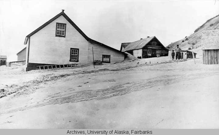
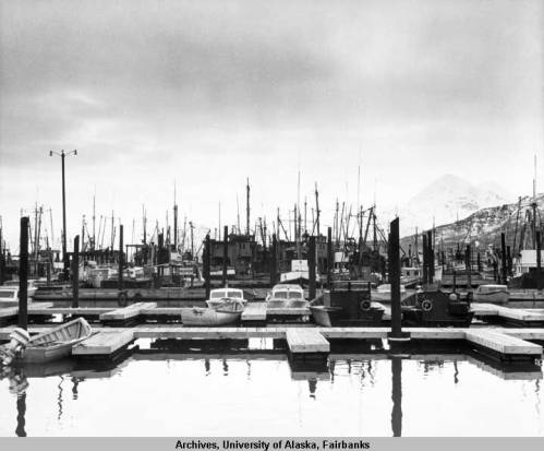
Growden Memorial Ballpark in Fairbanks is Alaska’s most historically significant sports venue. Its importance is rooted in the melding of two beloved American narratives: The Last Frontier and The American Pastime. These mythologies come together in the heart of Alaska and set the stage for powerful storytelling.
Hall of Famer and former Goldpanner Dave Winfield tries snowshoe baseball during a return visit to Fairbanks in 1984. Courtesy of the Alaska Goldpanners, Fairbanks, Alaska.
Built-in 1961, Growden Memorial Ballpark is home to the world-famous Midnight Sun Game, the Alaska Goldpanners, and spawning ground for over 500 MLB players, coaches, and umpires. The storied ballpark is where generational talents—such as Harold Reynolds, Bill Bean, Jason Giambi, Tony Francona, Alvin Davis, Dave Kingman, Bill “Spaceman” Lee, Barry Bonds, Bob and Brett Boone, and Hall of Famers (Terrific) Tom Seaver and Dave Winfield—donned Alaska Goldpanners jerseys. "To me, the Cy Young Award is the most important award a pitcher can attain, and I realize that my success is due to hard work, concentration, hard work, the right attitude, hard work, and, of course, opportunity. And your program, Red, was a vital step in my progress toward reaching a world championship, especially the Cy Young Award of 1969."
-Tom Seaver to Alaska Baseball League Founder Red Boucher,
October 31, 1969
Tom Seaver, Alaska Goldpanners program cover. Courtesy of the Alaska Goldpanners, Fairbanks, Alaska. Alaskans, however, have always played a more rugged brand of baseball. Freshly cut evergreen fields and youthful 'boys of summer' rarely spark reminiscences of the national pastime in the polar region. Few Alaskans wax nostalgic for a bygone age. We carved diamonds from the wilderness. We play ball at midnight and transform fields from ice and snow. Newcomers encountered a unique northern landscape within familiar diamonds, changing the game into something distinctively Alaskan. These stories tell us that Americans might have introduced the national pastime to Alaska, but we Alaskans, as Walt Whitman wrote, made it our game.
Rolling the Anchorage ballfield Alaska style, ca. 1920. Courtesy of the Anchorage Museum. Indigenous Baseball
Before Americans brought baseball north, Alaska Natives played Anauligatuk or Anau, described as a mix of cricket, dodgeball, and baseball. Alaska Natives from the southern areas of the state call the game Laptuuk. The game is generally known as "Eskimo Ball" and "Aleut Ball."
Sealskin softball. Courtesy of the Anchorage Museum.
The Indigenous version of baseball likely came to Alaska through two different routes: The Russians introduced to the Unangan and Alutiiq people of coastal Alaska an ancient batting game called "Lapta," which dates to the 14th century. By the late 19th century, Sami reindeer herders from northern Scandinavia introduced to Inupiat, Inuit, and Yupik people a game they call "Lapp Ball." The two versions likely came from the same Siberian source.
Historically, indigenous baseball is tied to colonization, but generations of Alaskans passed down this game and shaped it into a cultural expression of their own. The game continues to have a presence in rural Alaska. Indigenous Baseball instills among residents what one observer described as "a feeling of togetherness, which participants—players and spectators alike—share."
Whale Pennant illustration, published in "Spalding's Baseball in Alaska," 1911. A Whale of a Game
The first known competition comes from Hershel Island, on the Arctic Ocean, where Icebound whalers spread ashes on the sea ice to form a baseball diamond, where they played at 40 below to pass the time. Seven clubs were organized and formed into a league called the “Arctic Whalemen’s Pennant. “These games continued all winter until the ships left for summer whaling in July.
The world watches whalers play ball. General Frederick Funston, Harpers Round Table, 1899.
Eyewitness to the games was Brig Gen. Frederick Funston, who arrived at Hershel Island after a snowshoeing trip across northern Alaska in 1894. In 1899, Gen. Funston penned an article about the Whaler's Baseball League for Harper's Round Table. Albert G. Spalding, the founder of the sporting goods and manufacturing company, reproduced it in his game-defining 1911 classic, Base Ball: America's National Game. The article highlighted the spectators- those Funston called "typical "Base Ball cranks."
"I saw was the crowd of several hundred people watching our national sport, at this far away corner of the earth, only twenty degrees from the pole, and thousands of miles from railroads or steamship lines…And this crowd was more widely cosmopolitan than could have been found at any other place on the globe."
--Brig Gen. Frederick Funston, 1899
Anchorage-July 4, 1915. Photo by Sydney Laurence. Courtesy of the Anchorage Museum. Americanization
With the rush for gold into the Interior and the reds along the coast, baseball accompanied settlers who came to Alaska to explore, mine, fish, or work on the railroad. Baseball helped transform isolated work camps and canneries into integrated American towns. Residents turned out for games with enthusiasm—particularly the 4th of July tournament, the celebration’s centerpiece. As town identities emerged, rivalries formed among communities, linking Alaskans across the Territory.
Fourth of July Game in Valdez, ca. 1910. Courtesy of Geoff Bleakley.
In a diary entry dating to the early 20th century, Copper Center resident Joesph A. Bourke described the community's 4th of July program, which included races, pole climbing, tug of war competition, and a Baseball game. Explaining "why we celebrate the 4th," Bourke wrote of his fellow Alaskans, "We are all enthusiastic American Citizens. At least they all pretend such!"
Baseball grounds Nome. Glenbow Archives. Courtesy of Terrence Cole.
From Nome to Anchorage, baseball helped to "Americanize" Alaska. During the Gold Rush, Nome miners scrapped away soggy vegetation from the surface of the ancient beach ridges, placed hundreds of burlap bags atop the permafrost, and then piled dirt atop the bags to craft a playable ball field that overlooked Dry Creek. Historian Terrence Cole described the Nome field as "one of the most unique parks in the world."
Anchorage-Ship Creek field, July 4, 1915. Photo by Sydney Laurence. Courtesy of the Anchorage Museum.
Likewise, in Anchorage, renowned Artist Sydney Lawrence photographed a baseball game on July 4, 1915, the railroad town's founding. Over one hundred spectators lined up from first base to third. Behind the perfect diamond and the spacious outfield stood a tent city, and behind that, the seemly impenetrable Alaska wilderness.
Diamonds carved from the Wilderness. Chitina Baseball Park, ca. 1914. Courtesy of Geoffrey Bleakley. Home Fields
While baseball helped to Americanize Alaska, the extreme northern environment set Alaska baseball apart from America’s Game. In Ketchikan, teams competed on tidal flats until the rising Pacific Ocean ended the game. Though fans were accustomed to the game’s unhurried rhythms and timeless pace, the mighty Pacific Ocean was not. Matches that went too long were often called on account of the rising tide rather than nine innings, and each time, the baseball field was made new.
Ketchikan’s baseball grounds at low tide. Courtesy of Terrence Cole.
At Kennecott, copper miners played atop a glacier. In Fairbanks, teams played under the midnight sun. Writers trumpeted Alaska baseball's uniqueness to promote the territory in the Lower 48.
Playing on Kennicott Glacier, ca. 1920. Alaska State Library.
Witnessing the unusual, late-evening start time was considered an Alaskan rite of passage, as journalist H.C. Jackson explained in a 1913 article for Sunset Magazine:
"Here in this camp, we hold that besides seeing a freeze-up and watching the ice go out in the spring, a cheechako must sit through a midnight ball game before he can class as a sourdough."
Passengers playing on Bering Sea ice, Glenbow Archives. Courtesy of Terrence Cole.
Baseball wasn't sequestered just to summertime; Alaskans played baseball year-round. During the winter of 1900, a team of soldiers battled a squad from the Alaska Commercial Company in mid-February. It was so uncomfortable that the pitcher for the Alaska Commercial Company, Lois L. Lane, froze his fingers, and the contest was postponed until the arrival of milder weather.
Playing Baseball in Attu, 1943. The New York Bureau. U.S. Navy. World Wars
The U.S. military transported baseball to the farthest reaches of Alaska. Forts and bases often built fields and supported teams. During World War I, The Anchorage Daily Times asked readers to send baseball paraphernalia to troops in France. Baseball, according to the paper, gave idle soldiers a modicum of amusement and kept them out of trouble. More importantly, baseball ensured the American soldier did not forget his country’s customs and traditions. The 1917 article went so far as to predict that "sports will win the war."
Sea Bees break out baseball gear at Amchitka, Aleutians, ca. 1943. Courtesy of Candy Waugaman.
During World War II, baseball brought a modicum of normalcy to soldiers stationed on the Aleutian Islands, far from familiar hometowns. Along with weapons, artillery, and other necessary armaments for battle, enlisted men considered baseball gear a priority. Playing baseball helped soldiers cope with the pressure of war.
Welcome Satch! Anchorage Tournament Program. August 27- 29, 1965.
"I watched from the third base fence. Batter after batter went down swinging. After the game we paid our respects. He stood in the infield signing autographs. He smiled when he autographed my ball and program. An Anchorage boy’s dream fulfilled."
--Pat Osborne, on how he met Satchel Paige in 1965.
Welcome Satch!
As Alaska’s residents took to baseball, they rejected social and racial barriers that permeated parts of America in the first part of the 20th century. The Alaska Railroad, mining camps, and salmon canneries gave women, African Americans, Asians, and Alaska Natives opportunities to work and play. Alaska baseball afforded Emmett Ashford, the first Black umpire in MLB, a stage to hone his famous style.
Emmett Ashford. Courtesy of the Alaska Goldpanners.
Race and baseball also combined to create one of the great moments in Alaska sports—when Anchorage welcomed the legendary pitcher Satchel Paige to play in a four-game exhibition in 1965, just one year after the great Alaska earthquake. Rumor had it that the legendary pitcher might manage a team named for the natural disaster.
"Paige to Lead City’s Team," Anchorage Daily News, August 27, 1965.
"I loved Anchorage at first sight," Paige told the Daily News-Miner, "and I'm the man who can build this team up. I’m the man who knows the baseball players and can get them to come up here to play."
Paige's promise to start building the new Anchorage Earthquakers "the minute he left Alaska" never panned out. Still, his presence in Alaska helped to draw interest in the new Alaska Baseball League.
"Anchorage Glacier Pilots, named for famed aviator Bob Reeve, expanded the Alaska Baseball League in 1969. Courtesy of the Anchorage Glacier Pilots. A League of Our Own
A formal Alaska Baseball League started with the Alaska Goldpanners, founded in Fairbanks by Henry Aristide "Red" Boucher and Don Dennis in 1960. After adding the Anchorage Glacier Pilots in 1969, the league expanded to include the Peninsula Oilers, the Mat-Su Miners, the Anchorage Bucs, and, most recently, the Chugiak Chinooks.
Mark McGwire baseball card.
The Alaska teams assembled some of the best collegiate talent in the country. Alaska teams competed for numerous National Baseball Congress World Series titles at Wichita, Kansas, with the first championship won by the Anchorage Glacier Pilots in 1969.
Randy Johnson and Aaron Judge baseball cards.
Since then, many players and coaches have gone on to successful careers in the Major League. In addition to the famous Goldpanners, the Alaska Baseball League competition also cultivated the careers of other MLB icons, including Graig Nettles, Mark McGwire, Jacoby Ellsbury, Hall of Famer Randy Johnson, and future Hall of Famer Aaron Judge. They are just a few who found fame playing baseball under the midnight sun.
Surprising Demographics
Today, Alaska boasts some of the most diverse areas in the country, with over 100 languages spoken in several Anchorage neighborhoods. In addition to Yupik, Dena’ina, Unangax, and Inupiat, Spanish, Korean, Tagalog, and Hmong are spoken in Alaska classrooms. Notably, Alaska’s diversity and the origins of our immigrant population are often represented on our playing fields.
Jamar Hill Baseball Card.
This is particularly true for Anchorage resident and former New York Mets, Jamar Hill. The former Alaska athlete runs Nike RBI Alaska, which promotes youth baseball and softball. Hill is spearheading a project to build a $1.5 million community center in Mountain View that will give youth the opportunity to practice baseball year-round. Mountain View is considered the most diverse neighborhood in the United States.
The Bleachers at Ship Creek, ca. 1915. Anchorage Museum.
Sports and recreation like baseball cultivate unity. Former player Bob Feller once described baseball as a new opportunity: "You can build on yesterday’s success or put its failure behind you and start over again." Such optimism also underlies the story of Alaska: A place where disconnected people sought second chances and found in common the ability to overcome barriers and dream big. Perhaps the game is beloved by Alaskans because baseball, like the Last Frontier itself, is about heroes, renewal, and second chances. While surprising to some, Alaska has always been a gathering place for diverse individuals filled with similar hopes and dreams.
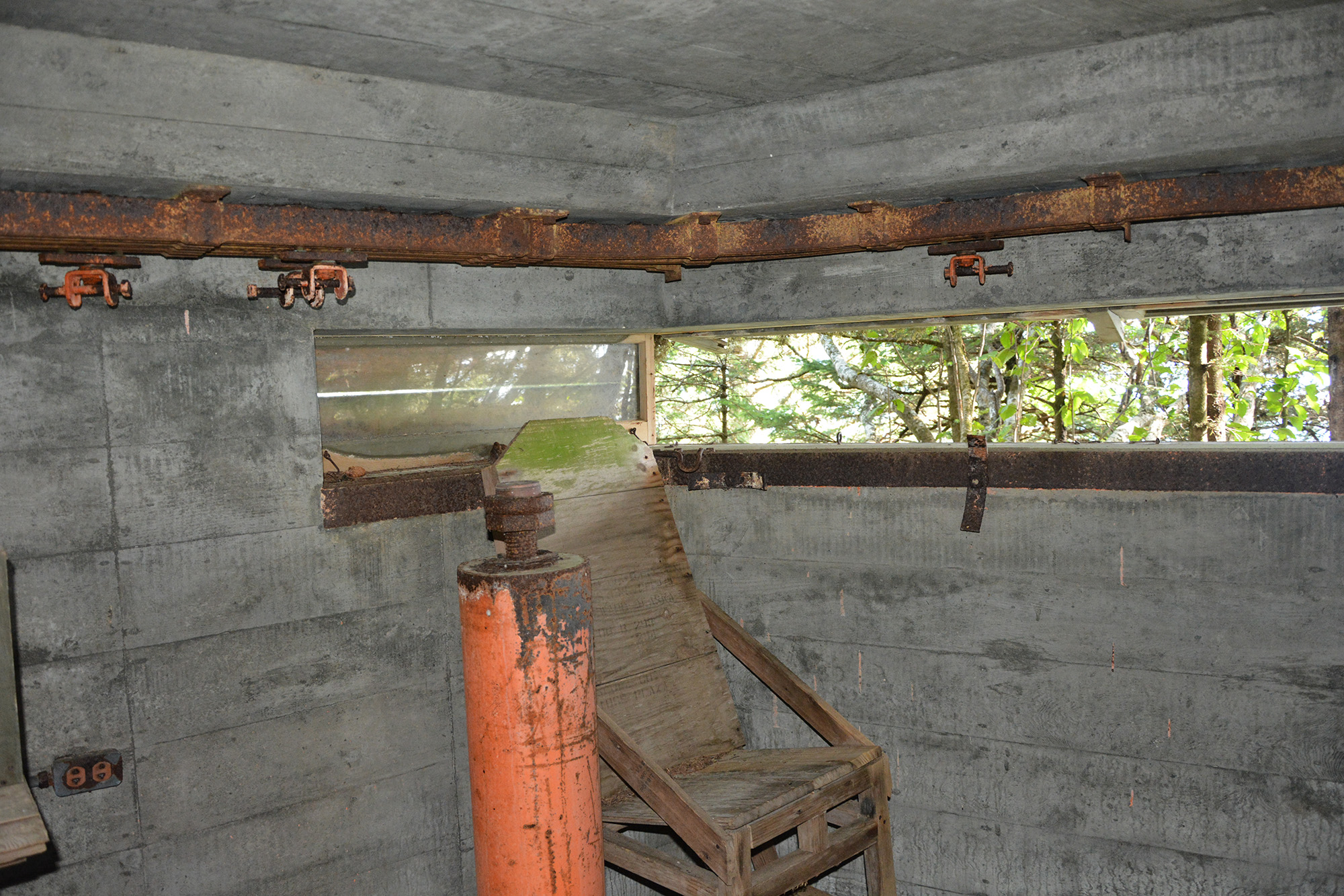
The Press Box at Growden Park is an enduring historic architectural feature that makes the field eligible for listing in the National Register of Historic Places. Photos taken at the Midnight Sun Game on June 21, 2024. Courtesy of the Office of History & Archaeology, Anchorage, Alaska. Preserve It, and They Will Come
As part of Alaska’s participation in the America250 celebration, the Office of History and Archaeology is partnering with the Alaska Goldpanners to nominate Growden Memorial Ballpark to the National Register of Historic Places. Once listed, the storied stadium will be eligible for Certified Local Government grants, Historic Preservation Fund grants, tax credits, and other funding to restore the field to its 1960s-era minor league glory and modernize facilities for today’s fanbase.
Importantly, we believe efforts to preserve Alaska’s most significant sports venue will encourage collaboration with private businesses, local governments, and nonprofit organizations to develop a heritage tourism sports program that will expand the ballpark's use beyond the short summer season and serve as a potential site for local, statewide, national, and international tournaments, concerts, and exhibition halls to immerse heritage-seeking visitors in Alaska's history and culture while benefiting businesses, communities, and youth programs. The historic preservation and modernized improvements of the Fairbanks facility could also lay the foundation for a Field of Dreams game at Growden Memorial Ballpark in the future.
From an early age, baseball shows there is hope right up to the last pitch and reminds the young and the young at heart to believe in miracles. Courtesy of the Anchorage Museum.
"The history of interior Alaska is the history of its river communities and ghosts of travelers who have left nothing more than footprints and legends."
--Michael Letzring, Historian
Historic Chena Building National Register Nomination
February 2024
The Chena Building, a remarkable survivor, stands as a testament to the commercial properties of interior Alaska during the gold rush era. Its resilience is evident in its journey from the establishment of Chena in 1905 to the town's fall, a period marked by its interpretive value and the significance of its rediscovery and return to the original historic townsite after more than 100 years. This unique journey supports the Chena Building's nomination under Criteria A, making it a truly exceptional piece of history. Photo by Micheal Letzring. February 2024.
The small, unassuming, and yet remarkably resilient Chena Building, constructed between 1904 and 1907, stands at the heart of a parking lot at the Chena Pump State Parks wayside, situated at the confluence of the Tanana and Chena Rivers, near Fairbanks, Alaska. The decrepit building currently rests on a temporary milled timber crib foundation. A temporary shed roof shelter has been constructed to protect it from the elements and prevent further damage caused by heavy snow loads.
The Chena Building, strategically nestled on the banks of a bend in the Tanana River, offers visitors uninterrupted views South across the Tanana Valley to the Alaska mountain range, 70 miles away. Its location, ideal for historic riverboat traffic, and its modern use as a public boat landing, illustrate the importance of river transportation even in 21st-century Alaska. Photos by OHA staff in May 2021 and February 2024 illustrate a seasonally diverse riverscape.
While the Chena Pump State Parks wayside currently serves as a state-maintained picnic shelter and boat launch, it holds a forgotten, yet significant past that the Chena Building helps us recall. Buried beneath the surface of hard ground and river lies the archeological remains of the lost town of Chena. To our knowledge, the 120-year-old Chena Building is the last surviving standing building of the once-thriving river-to-railroad community. It is a physical, economic, and historical link to the past, intricately tied to Fairbanks, the gold rush, and the American West.
Interior Alaska's First River-to-Railroad Town
A monumental shift occurred in interior Alaska's landscape in the first years of the twentieth century. After the Klondike and Nome gold rushes, gold prospecting activity reached deep into interior Alaska, leaving an indelible mark on its history. A series of modest gold discoveries in hills and valleys between the Yukon and Tanana Rivers, culminating with the strike by Felix Pedro only about 20 miles north of the present-day Fairbanks, attracted a steady stream of prospectors and traders that relied on water transport and river towns that sprang from river commerce.
U.S. Geological Survey Map, 1908, showing Chena, Fairbanks, and the Tanana Valley Railroad line locations.
The lure of gold led to the establishment of two townsites that would become transportation and supply centers for mining activity in the middle Tanana region. The best known (and only survivor) of the two communities, Fairbanks, was founded by entrepreneur E.T. Barnette when he established a trading post on the banks of a tributary of the Tanana—the Chena River—in the prospecting season of 1901.
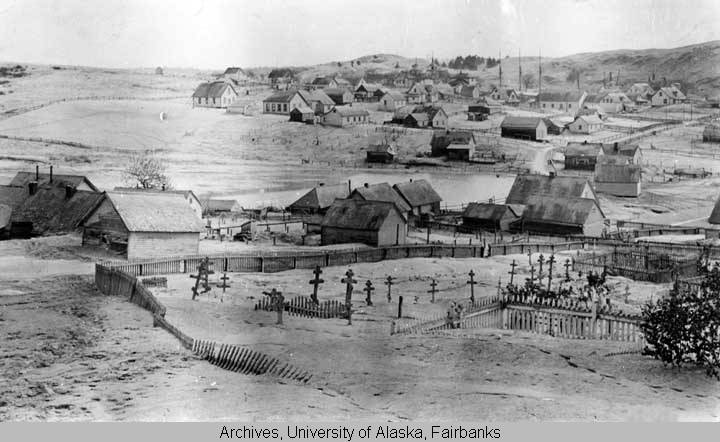
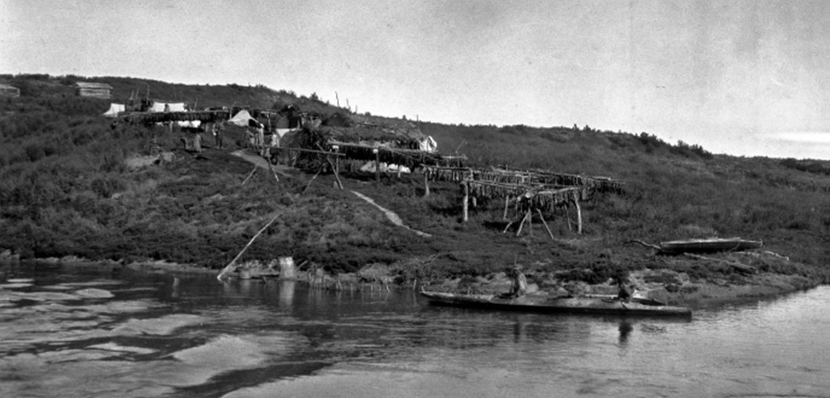
The historic town of Chena, Alaska, ca. 1905. Period photographs reveal a bustling railroad depot and waterfront lined with paddle-wheel steamboats, all part of the vibrant community nestled under clouds of wood smoke. The denuded surrounding landscape, a clue to the primary power source and construction material, adds to the historical context. The location of riverfront docks and warehouses in the image is now beneath the Tanana River, further highlighting the historical changes in the area.
Approximately 9 miles downstream from Fairbanks was the town of Chena, which began as a trading post at the confluence of the Chena and Tanana Rivers. The Hendricks and Belt trading post founded by N.V. Hendricks and George Belt was established only months before E. T. Barnette's venture. Initially settled to engage in the fur trade with a nearby Native village, the future Chena townsite's chief advantage over Barnette's trading post (the future Fairbanks) was more reliable water depth ideal for mooring deeper draft river boats that delivered people and supplies from as far away as St. Michael on the Yukon River. There is some evidence that Barnette would have preferred the Chena site but was beaten to the location by Belt and Hendricks.
Chena's primary advantage over Fairbanks was its more reliable water depth for passage by larger riverboats. There is some evidence that E.T. Barnette, founder of Fairbanks, would have preferred the Chena site but was beaten to the location by Belt and Hendricks. This historical context sheds light on the Gold Rush era's competitive dynamics and the Chena site's strategic importance.
In part because of the Chena townsite's superior boat harbor, several commercial ventures chose it as the terminus for shipping and warehousing of supplies. Late in the 1903 season, entrepreneurs Falcon Joslin and Martin Harrais traveled from Dawson, Yukon Territory, Canada, to the Chena region to evaluate the potential for building a railroad. After returning to Dawson and securing financial backing, Joslin and Harrais began construction in 1904 of the Tanana Mines Railway, the first operational railroad to serve the gold camps.
Sanborn Insurance Co. commercial map of Chena townsite, ca. 1905. Courtesy of the University of Alaska Fairbanks
The extensive supporting facilities for the Tanana Mines Railway and riverine docks and warehouses drove a flurry of construction in Chena through 1904 and 1905, culminating with the arrival of the first steam locomotive in July 1905, which accelerated the development of both Chena and the rail line. The town of Chena continued to grow in parallel with the fortunes of the Tanana Mines Railway, with a locomotive roundhouse and riverside depot, telegraph station, sawmill, stores, restaurants, and dwellings, so that by 1907 more than 120 structures filled out maps of the townsite, and population estimates are as high as 1000 residents. The Chena Building, constructed to serve the expanding riverside settlement, would be perched among the boardwalk maze.
Mainstreet Chena, ca. 1905. The historic Chena townsite served as a central transportation hub for interior Alaska between 1903 and 1920, serving all the Tanana basin gold-rush communities as head of the first operating railroad in interior Alaska.
Chena's scarcity of finished lumber materials and competition for space along the unimproved street fronts resulted in rows of side-by-side business concerns jostling for customers and commerce. Shopkeepers, hotel proprietors, and other businesspeople were often reluctant to invest heavily to erect a place of business in a new and uncertain location. Still, the new arrivals wished to project an image of stability and success to prospective clientele and create a more urban atmosphere. Once construction methods advanced beyond tents and log buildings, usually with the advent of a local sawmill or railroad access, commercial building owners would budget their spending for impressive facades while relegating the secondary sides and back of the building to more practical treatment.
Symbol of American Capitalism
The last vestige of the bustling Chena Townsite is the humble Chena Building. At first glance, the building appears rundown and decrepit. Still, it retains an essential character-defining feature—its false front, an architectural symbol of American capitalism.
The Chena Building's architectural style reflects the conditions and visual language of early 20th-century boomtown commerce: the exaggerated vertical false front disguised the modest interior floor plan and economical half-gable roof. Today, the Chena Building represents the oldest false front commercial building in Alaska's interior region and one of the five oldest buildings in the Fairbanks area. Photo by OHA staff, April 2024.
The Chena Building's false front directly links interior Alaska to an icon of the urban pioneering American West and represents the reach of American capitalism and culture into the region. Commercial buildings with the familiar false front architectural style were constructed in mountain mining towns, plains agricultural communities, and early railroad centers from the late 19th to the early 20th century. While false front architecture is deeply associated with the American West, the style is rooted in 19th-century classical European architecture that drew inspiration from building styles of the 16th-century Italian Renaissance that created continuity and expressed in the Age of Empire the spoils of global commerce and colonization.
The Chena Building in ca. 2019. The local Fairbanks residents donated the Chena Building to the State of Alaska and gave it the moniker the "Old Timer." Courtesy of Patty Peirsol.
The narrow, false front style of the Chena Building underscores the town's historic commercial purpose—its raison d'etre. Faced with a scarcity of finished lumber materials and fierce competition for space along the unimproved street fronts, the Chena community displayed remarkable resourcefulness. Rows of side-by-side business concerns were established, each vying for customers and commerce, a testament to the town's entrepreneurial spirit.
The Bust
Like numerous other mining ghost towns, Chena busted nearly as fast as it boomed. Between 1903 and 1917, Fairbanks received federal backing by establishing the District Court, the Alaska Railroad, and the Alaska Agricultural College and School of Mining (University of Alaska). Chena, on the other hand, began to wither. Most commercial buildings in the river community were associated with railroads or materials warehousing. After the narrow-gauge railway spur shut down to Chena, much of the commercial district became redundant. With the demise of the Tanana Valley Railroad during World War I, there was no longer a need for the warehouses and docks that lined the riverfront or the railway terminal and support facilities.
Chena Building Interior, October 2019. Courtesy of Patty Peirsol.
The high price of building materials in Fairbanks (and throughout Alaska territory) made it economically sensible to salvage unused buildings wherever gold booms had "played out." The relatively short distance up the Chena River made it possible to transport complete buildings by barge to the still-expanding city of Fairbanks, and residents may have salvaged many structures for local construction or even firewood. The Chena Building was probably moved from the Chena townsite to Fairbanks city after the liquidation of Tanana Valley Railroad (1917), signaling the final chapter in Chena's brief history.
The Chena townsite followed the railroad's fate, which was once its heartbeat. Resident workers moved to the rival town of Fairbanks and gradually abandoned Chena, returning the townsite to the natural cycles of river flood and reforestation.
In subsequent years, the meandering course of the Tanana River with frequent seasonal flooding obliterated all that remained of the Chena townsite. Aerial photographs from 1949 only show faint traces of one street and the Tanana Valley railroad bed that Chena Pump Road now overlays. Produced by OHA staff.
The Chena Building was one of the buildings saved from rising river waters and encroaching vegetation. It endured at least three moves in its post-Chena lifetime, serving as a support building at Weeks Field for a stint and finally settling in a Fairbanksan's backyard, forgotten and disregarded, like its hometown, for over 70 years.
The Chena Building in 2018 at the Barnette Street home of Alaska Stewart Linck and her son James "Jim" Moody. Courtesy of Patty Peirsol.
But thanks to the historical intelligence of a thoughtful group of residents who identified its importance, the Chena Building was again saved. In a Herculean preservation effort, the building was returned to the location of the historic Chena townsite, much of which now lies within Alaska State Park lands.
In November 2018, Fairbanks residents moved the Chena Building via trailer to the historic Chena Townsite. Courtesy of Patty Peirsol. Last Vestige of a Lost Town
Over the past 120 years, human and natural processes have nearly obliterated the historic Chena townsite, which today is primarily underwater of the shifting Chena channel and, therefore, more closely resembles the original boreal riverine habitat that was home to the local Dene groups when traders first established trading posts in the area at the turn of the 19th century.
"Chena Cabin." Fairbanks Daily News-Miner, November 11, 2018. (click to see article)
But rather than forgotten, archeologists and historians with the University of Alaska Museum of the North are currently investigating Chena's subsurface artifacts, hoping to identify the historic townsite's physical characteristics and develop a broader understanding of settlement and abandonment patterns, commodity flows, subsistence practices, and ethnicity, class, and gender relations in early 20th-century interior Alaska. Through detailed analysis of historical railroad and civil surveys, it has been possible to recreate the townsite street plan, which is now occupied partly by the Alaska State Parks Chena Pump wayside. Researchers may never establish the Chena Building's precise original position. Still, its return to the Chena Townsite location is essential in preserving its integrity while being an unforgettable reminder of the area's lost past.
Chena Building site map, 2024. Because the Chena Building was moved, returned to the lost townsite near its believed historic location, and placed in its original orientation, the property has significant and rare interpretive value. Map by OHA staff.
The present location of the Chena Building in the Chena Pump Road wayside and public boat landing brings the story of the Chena Building full circle: all of the physical characteristics of the location on the main stem of the Tanana River that initially attracted Euro-American traders and riverboat traffic are present and still being used by Alaskans year-round. Townsites with riverboat landings trace the history of interior Alaska, and the story of interior Alaska remains inextricably intertwined with the story of riverboats, early railroads, and the town of Chena.
Archeological surveys, excavation, and Ground Penetrating Radar imaging have revealed extensive preservation of intact features and assemblages at the Chena Townsite. The current multi-year project conducted by the Department of Anthropology at the University of Alaska Fairbanks is working to ground-truth Chena's tangible resources with historical mapping, generate Chena's ethnographic story through archeological, archival, and oral history sources, and nominate the Chena Townsite Historic Archaeological District to the National Register of Historic Places. The study of the Chena Building enhances researchers' understanding of the area. The photo shows newspapers found on the Chena Building's flooring that help researchers create a historical timeline. Courtesy of the University of Alaska Fairbanks.
Without a doubt, understanding the history of Alaska's inland empire starts with Fairbanks, and substantial evidence exists that the mining and mercantile commerce that Fairbanks relied upon were tied to Chena's deeper harbor and the Tanana Valley Railroad headquartered there. While it remains an open question whether the establishment of Fairbanks would have been possible without the prior development of Chena, the Chena Building, now resting in the heart of the historic Chena Townsite, provides a final and important interpretive doorway to understanding the patterns of history sculptured by the rivers of interior Alaska.
Historic Chena Building Sketch, 2019, by Fairbanks artist and Alaska Historical Commission member Ray Bonnell. The Chena Building is the last remaining building from the original Chena Townsite and represents one of a handful of pre-World War I structures in the Fairbanks region. It was placed on a parcel of Alaska State Parks land (the Chena Pump Wayside) that closely corresponds with the original townsite of the gold rush era in Chena.
Despite showing its age, the building still emotes the feeling of the rise and fall of an interior Alaskan boomtown and its bust. Alaska's early river communities were faced with a constant struggle against the forces of nature but, at the same time, served as ports of entry for a multitude of human dreams and ambitions.
As historian Michael Letzring writes, "The history of interior Alaska is the history of its river communities and ghosts of travelers who have left nothing more than footprints and legends."
But thanks to Alaska State Parks, preservation-minded residents, and the tangible reminder represented by the Chena Building, the story of Chena and the people who enlivened it will not be forgotten.
The content for this essay came from the Historic Chena Building National Register Nomination authored by Michael Letzring, PhD. The Alaska Historical Commission will consider the nomination for listing in the National Register of Historic Places on October 3, 2024.
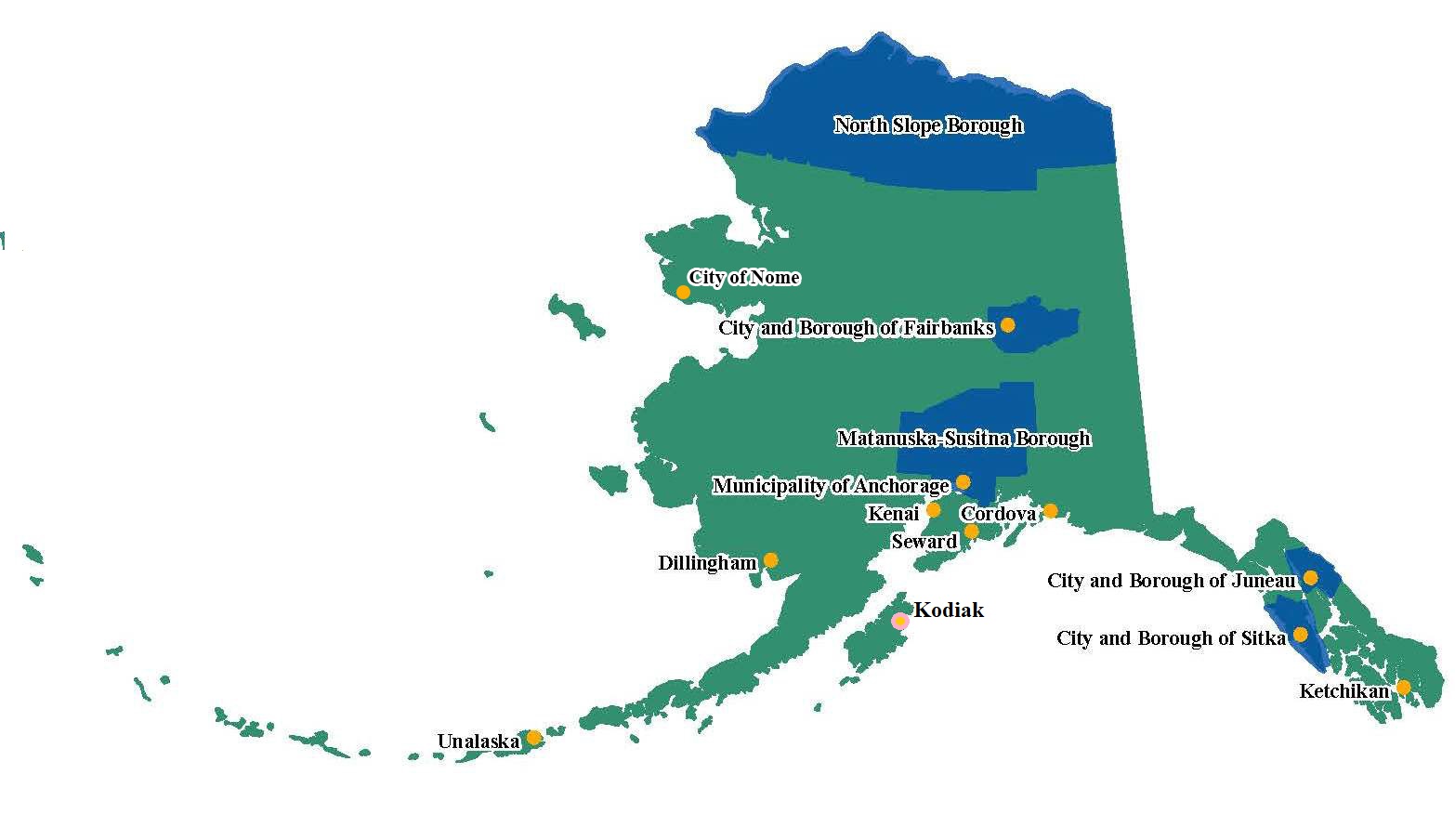
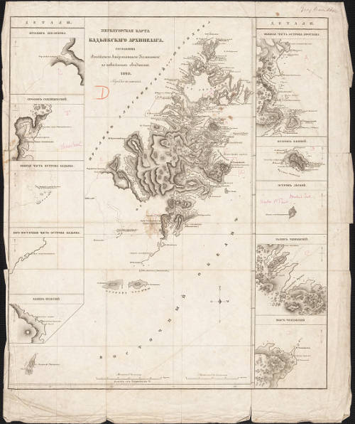
Revised map including Kodiak as the 15th Certified Local Government, courtesy of Alaska Office of History and Archaeology.
On March 23, 2023, the City of Kodiak officially became the fifteenth Certified Local Government (CLG) in the State of Alaska, boosting historic preservation efforts for the southwest part of the State. Belonging to the CLG Program provides a link between local, State, and Federal governments that prioritizes cooperation and solidifies a commitment to protecting local historic resources for future generations.
The CLG Program is an extension of the National Historic Preservation Act of 1966, which began including local administrations in 1980. These governments are found in every State, and by providing communities with a firsthand avenue for sustained historic preservation, they create mutual opportunities between all levels of government, the National Park Service, and their communities. For a local government to become certified, they must meet four criteria: follow state and local preservation laws, establish a qualified historical commission, maintain an adequate historical inventory, and represent preservation efforts locally.
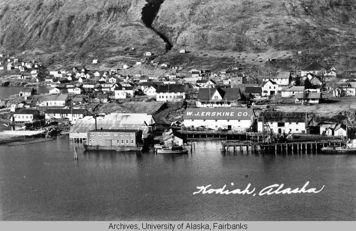
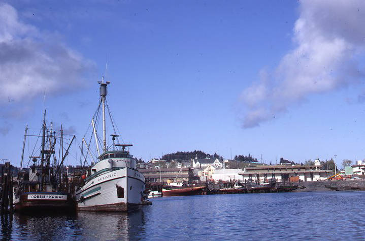
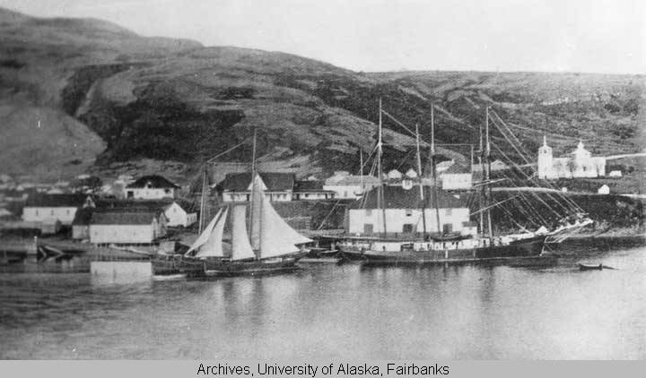
Views of Kodiak waterfront, circa 1940, with Russian Magazin visible. Image taken for a postcard, with a caption that reads "Kodiak, Alaska". Courtesy of University of Alaska Fairbanks, Alaska and Polar Regions Collections, O.B. Chamberlain Collection, UAF-1972-154-3.Kodiak's inner harbor, with vessels "Robbie" and "Oceanic" visible, taken in 1968. Image courtesy of Ruth A.M. Schmidt Papers, Archives and Special Collections, Consortium Library, University of Alaska Anchorage.
Through participation in this program, communities actively commit to preserving, safeguarding, and strengthening the distinct past closest to them. At the State level, CLGs work with the State Historic Preservation Office (SHPO) to help coordinate preservation, technical assistance, financial support, and the overall betterment of historic resources locally. Community involvement can translate into various projects, including National Register of Historic Places nominations, educational programs, rehabilitation work, surveys, and many others.
This certification means that Kodiak can enhance its preservation efforts and progress toward new conservation projects. As a CLG, Kodiak is eligible to receive backing from the Historic Preservation Fund (HPF), a federal fund allocated by the SHPO, through which 10% of grant funds go to Local Governments. Alaskan CLGs have received over $2 million in HPF grant funds between 1986-2018. Examples of projects that have obtained CLG funding include the restoration of the Government Cable House in Seward and the Rebarchek Agricultural Park Project in the Matanuska-Susitna Borough. This additional funding will allow for investments in Kodiak's past and future by making the City's cultural resources more identifiable, accessible, and intact.
A rich and tangible history exists in Kodiak, and becoming a CLG will open the community to new access points for education, funding, and historic preservation. Through these preservation endeavors, interest and connection to beneficial aspects of Kodiak's historic and cultural heritage can expand tourism, increase local enthusiasm, and sustain attention to historic assets.
Kodiak has contributed to the development of Alaska and the world in multiple contexts throughout history. Kodiak's thriving Alutiiq cultural heritage, role in North American colonialism, central position on the Pacific Front, and impact on the world economic stage in every period of its history contribute to its unique value. Kodiak has influenced the broader patterns of our collective past by providing provisions or subsistence to millions across time and history. The nineteen National Register of Historic Places sites and four National Historic Landmarks located near Kodiak are evidence of the ample history that has taken place, and becoming a Certified Local Government will ensure the protection of that past.
Kodiak Natural History
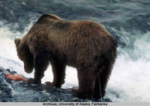
Kodiak has a vast history spanning centuries, technologies, and cultures. From the ancient Alutiiq settlements to the prominent fishing industry and beyond, Kodiak has seen a variety of landscapes, people, and events that have shaped it into a historic crossroads. Kodiak's history begins with the diverse natural landscape that continues to impact everyday life. Positioned about 90 miles southwest of the Kenai Peninsula and 40 miles from the Alaska Peninsula, the Kodiak Archipelago and Island were shaped by advancing glaciers during the Pleistocene Ice Age. Kodiak's terrain consists of rocky mountains, glacial valleys, nearby volcanoes, and diverse flora and fauna. A plethora of marine mammals, fish, crabs, and Kodiak brown bears are sustained by the incredible amount of biomass living under the ocean's surface.
A grizzly bear eating a fish; These bears can be distinguished by their prominent shoulder hump, and are most commonly found in Kodiak, other parts of Alaska, and western Canada. Image courtesy of University of Alaska Fairbanks, Alaska and Polar Regions Collections, Robert W. and Elizabeth L. Stevens Collec-tion, UAF-2003-194-5791.Photo taken in January 1956 by Arnold Granville, District Supervisor for the Alaska Department of Education. Taken across from Kodiak on Woody Island; Courtesy of University of Alaska Fairbanks, Alaska and Polar Regions Collections, Arnold Granville Photographs, UAF-1991-18-288.
Alutiiq/Sugpiaq History
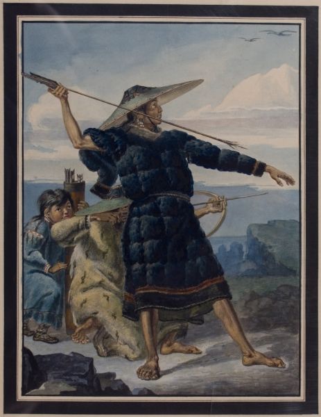
A full-body portrait done by M. Tikhanov, titled "Aleut in festive attire demonstrates hunting methods," 1818, courtesy of OHA Project, "Envisioning Alaska: Artistic Legacy of Russian America".
After the glacial melt over 7500 years ago, the ancient Alutiiq people migrated via kayak to warmer and drier Kodiak than the current one. Accustomed to living on the coast, hunters of the Ocean Bay Tradition (7500 to 4000 BP) used bone hooks, barbed harpoons, or chipped stone points to hunt for sea mammals and fish for survival. Their descendants, members of the Kachemak Tradition (4000 to 900 BP), refined the use of nets for fishing salmon and cod while developing trade partnerships with their mainland neighbors. Those of the Koniag Tradition (900 BP to 1784) were part of groups whose hereditary leaders ruled through warfare, ceremony, and trade. The Alutiiq often traded with other Alaska Native communities on the mainland for necessary raw materials, animal pelts, ivory, or glassy stones in exchange for fish, seal pelts, or weaponry.
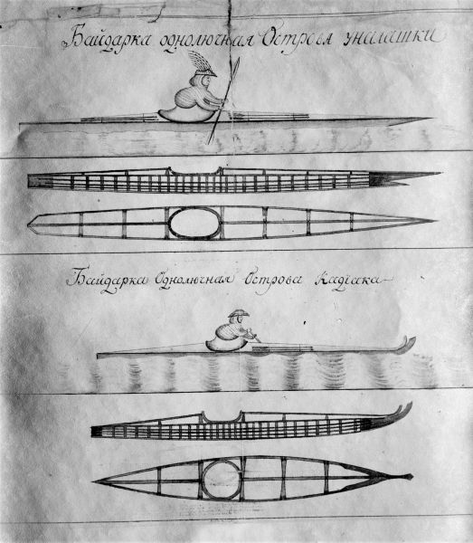
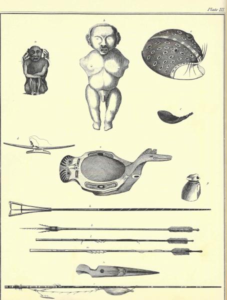
Drawing comparing Unangan (top) and Alutiiq (bottom) baidarkas, similar to present-day single person kayaks. J. Shields, 1770s-1780s, courtesy of OHA Project, "Envisioning Alaska: Artistic Legacy of Russian America".Sketches of hunting tools, a dish, and other figures done by Yuri Fedorovich Lisianski, published circa 1815, courtesy of OHA Project, "Envisioning Alaska: Artistic Legacy of Russian America".
Archaeological sites hold evidence of groups across the Island, but certain concentrations on both the east and west coasts, as these spots were advantageous for fishing and trapping, and whaling. Bands of families would travel to their fishing camps placed at optimal harvesting areas for summer and fall. There was a central village with housing to reside in during the cold winter months, typically at the mouth of the bay. The warmer seasons were better for harvesting and storing each year's yield, while the focus of the winter months was forging equipment and group ceremony. The rich cultural heritage of the Alutiiq/Sugpiaq people can be more deeply explored at the Alutiiq Museum and Archaeological Repository in Kodiak, a potential beneficiary of the CLG Program.
Russian Presence/Alaska Commercial Co.
After the discovery of Alaska by Vitus Bering in 1743, Kodiak Island became the first permanent Russian settlement for fur traders due to its central location between the Aleutian Islands and the Alexander Archipelago. Positioned near modern-day Old Harbor, a base for the Shelikhov-Golikov Company (1784-1799) was founded in 1784, lasting a decade- until Alexander Baranov took over Company management.
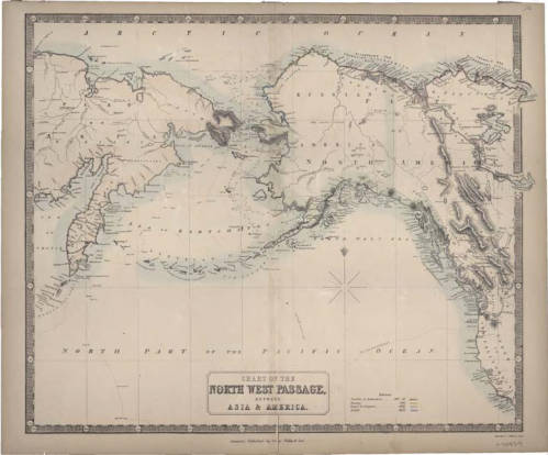
A 19th-century map of the Alaska, Russian Far East, and western Canada, captioned "Chart of the Northwest Passage between Asia and America", courtesy of University of Alaska Fairbanks, Alaska and Polar Regions Collections, Rare Maps Collections, UAF-M0593.Detailed Russian Map of Kodiak, derived from the annual report from the RAC, published in 1849. Image courtesy of University of Alaska Fairbanks, Alaska and Polar Regions Collections, Rare Maps Collec-tions, UAF-G4372 K632 1849.
Relocating the base to present-day Kodiak proved profitable as this location became the hub for fur receiving and transport. After renaming the Russian-American Company (RAC) business and receiving monopoly rights, the RAC began taking on additional colonial roles in governance and administration, including collecting taxes and enforcing Russian law.
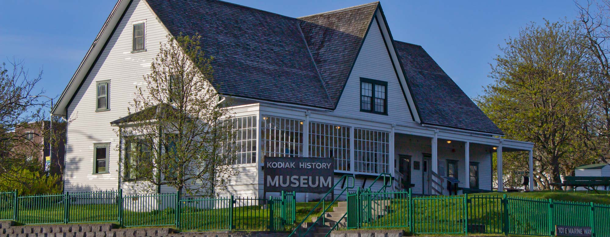
Even after RAC headquarters relocated to Sitka in 1804, Kodiak was still considered the most populated Russian settlement, and the construction of a magazin-- a storehouse for furs-- proves Kodiak's continued importance during this time. This magazin, built circa 1808, still stands today, is the oldest log structure on the West Coast of North America, the earliest Russian-built structure, and the oldest building in Alaska. It is currently being used as the Kodiak History Museum, and is pictured below in 1893, directly behind the smaller of the two ships, and a more current image from 2019.
Drawing comparing Unangan (top) and Alutiiq (bottom) baidarkas, similar to present-day single person kayaks. J. Shields, 1770s-1780s, courtesy of OHA Project, "Envisioning Alaska: Artistic Legacy of Russian America".A current image of the Russian Magazin, taken in 2019. The Magazin has been considered a National Historic Landmark since 1962, and this photo is courtesy of the Kodiak Historical Society.
The Alaska Commercial Company (ACC) took over all RAC assets following the Alaska Purchase in 1867 and effectively had the same corporate monopoly as its predecessor. The ACC had business throughout the territory but continued to serve as the institution that maintained order until Congress established the Alaska District Court in 1884.
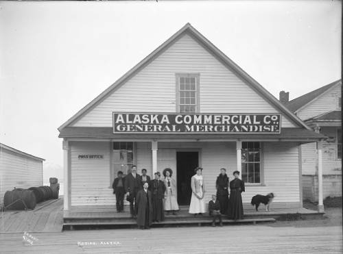
A group of people standing in front of the Alaska Commercial Company storefront in Kodiak, taken circa 1890. The ACC took over may of the governing duties from the RAC. Image courtesy of University of Alaska Fairbanks, Alaska and Polar Regions Collections, Mary Whalen Collection, UAF-1975-84-691.
Katmai Eruption
On June 6, 1912, the largest volcanic eruption of the twentieth century occurred across the Shelikof Strait on the Alaska Peninsula, creating what we know now as the Valley of the Ten Thousand Smokes. Located only 100 km from Kodiak, prevailing winds blew three days of erupting material over the Island, darkening skies and covering the green summer landscape with several feet of ash—even collapsing buildings. Ash from this eruption traveled from Novarupta—Latin for new eruption—to as far as Greenland, Europe, and North Africa.
Ash covering buildings and the ground following the 1912 Katmai Eruption. A man and a child can be seen in the middle-right of the image, courtesy of University of Alaska Fairbanks, Alaska and Polar Regions Collections, Amelia Elkinton Collection, UAF-1974-175-398.A graveyard and many homes are covered in ash from the 1912 Katmai Eruption. Image courtesy of University of Alaska Fairbanks, Alaska and Polar Regions Collections, Amelia Elkinton Collection, UAF-1974-175-376.
WWII on Kodiak
World War II had an immense impact on Alaska, which can be seen and felt through its unique history on Kodiak. Military operations in Kodiak were essential for monitoring possible enemy attacks as tension grew in the Pacific. Construction of the Kodiak Naval Operating Base began in 1939, with Fort Greely's and Miller Point's (eventually Ft. Abercrombie) development beginning two years later. In November of 1941, just a month before the attack on Pearl Harbor, Miller Point began functioning as an observation post and as the headquarters battery, responsible for maintenance, administration, and support, and quickly became the principal Naval base of the North Pacific sphere.
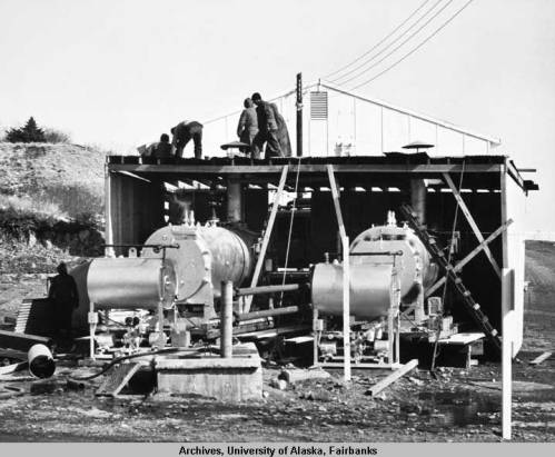
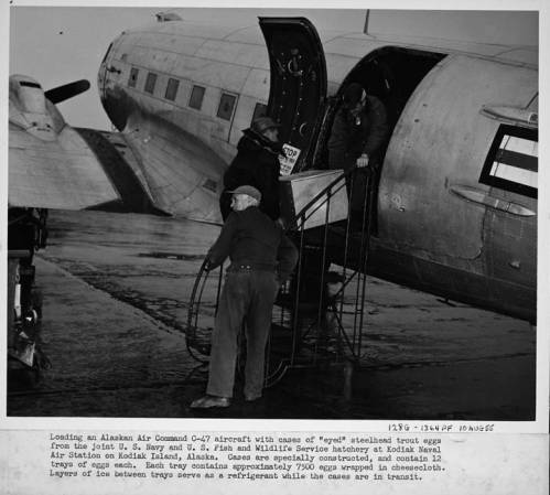
Soldiers working on portable boilers to supply U.S.Naval Station housing with heat, an official U.S. Navy photograph. Image courtesy of University of Alaska Fairbanks, Alaska and Polar Regions Collections, Alaska Earthquake Archives Committee Collection, UAF-1972-153-49.Three men loading a steel box onto an Alaska Air Command C-47. This box contained trout eggs, and was done as a part of a project to supply various Alaskan lakes with rainbow trout. Image courtesy of University of Alaska Fairbanks, Alaska and Polar Regions Collections, Alaska Air Command Photograph Collections, UAF-1982-10-1.
Located strategically, the Kodiak coordinated the war effort between Fort Mears in Dutch Harbor to the west, and the Sitka Naval Operating Base to the east. The Kodiak Base also served as a joint operating center for the Navy, Army, and Airforce, complete with a submarine base, air station, and supervision of the North Pacific Force. At its peak, Fort Abercrombie had around 200 soldiers stationed, ready to defend the Alaskan territory against the Japanese and support the United States on the Pacific Front.
Following WWII, most of Kodiak's military fortifications were placed into caretaker status, meaning they were ungarrisoned but ready for future use. Fort Abercrombie was abandoned but became a National Historic Landmark in 1985 for its significant contributions to the war effort in Alaska. You can visit the Kodiak Military History Museum at Miller Point, Fort Abercrombie, and see their expansive collection of WWII in Alaska artifacts.
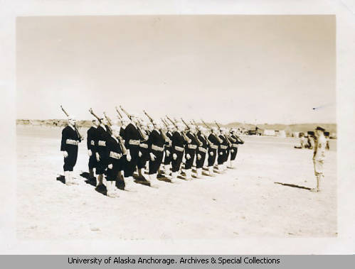
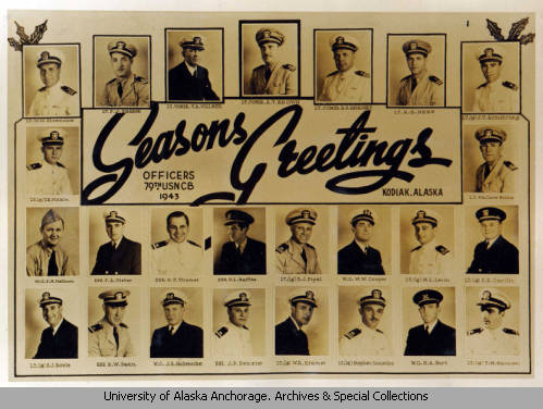
Photograph of a marching drill done by soldiers on Kodiak Naval Operating Base, circa 1943. Courtesy of George Gelbish photographs, Archives and Special Collections, Consortium Library, University of Alaska Anchorage.A composite photograph of soldiers who served in the 79th USN CB, taken in 1943, with the caption "Seasons Greetings". Image courtesy of James R. Denison Scrapbook, Archives and Special Collections, Consortium Library, University of Alaska Anchorage.
1964 Earthquake
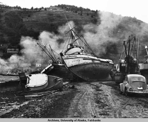
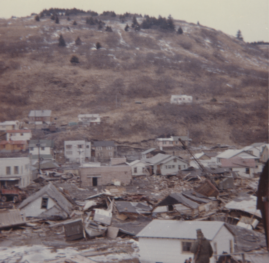
The Alaska 1964 Earthquake also impacted the landscape and community of Kodiak. On March 27, at 5:36 pm, this earthquake, with a magnitude of 9.2, was the largest U.S. earthquake ever recorded. With its epicenter in Prince William Sound, around 500 miles away, the people of Kodiak felt the shock of the earthquake immensely. Still, the real concern was the incoming tsunami waves and the need to move to higher ground. The water rose quickly, as many boats were drifting untethered, debris accumulated, and citizens feared for their future. Aftershocks were felt for months following, keeping the residents of Kodiak on edge. Many cultural resources are associated with the earthquake, as the necessary rebuilding of the City serves as a benchmark of Kodiak's history. This historic earthquake is still remembered vividly, impacting all of Alaska.
The "Albatross" fishing boat is beached following the earthquake and tsunami on March 29, 1964, with other wreckage, and a Volkswagen Beetle surrounding it. Image courtesy of University of Alaska Fair-banks, Alaska and Polar Regions Collections, Alaska Earthquake Archives Committee Collection, UAF-1972-153-218.Wreckage of homes on Kodiak following the Great 1964 Earthquake and Tsunami, courtesy of the Kodi-ak Historical Society.
Bustling Fishing Industry
Kodiak is known for the assorted fishing industry that has sustained its economy for centuries. Subsistence fishing has supported families from across the globe for generations, but modern profit-fishing in Alaska escalated significantly between the 1880s and the overfishing decline of the 1950s. The fishing industry is still incredibly prominent in Kodiak, as commercial fishing and processing make up most jobs in the City. Kodiak also has a rare advantage when it comes to fishing in Alaska, as businesses on the Island can operate year-round, unlike their seasonal Bering Sea counterparts.
A black-and-white photo of Kodiak Harbor circa 1960's, taken shortly before the 1964 Earthquake. Image courtesy of University of Alaska Fairbanks, Alaska and Polar Regions Collections, Alaska Earthquake Archives Committee Collection, UAF-1972-153-52.An aerial view of Kodiak and the Woody Island Channel, taken circa 1949. Homes, roads, and two boats in a cove can be seen. Image courtesy of University of Alaska Fairbanks, Alaska and Polar Regions Collec-tions, George A. Morlander Photographs, UAF-1997-108-538.
Commercial, recreational, and subsistence fishermen harvest multiple salmon species around Kodiak and King crab, halibut, pollock, cod, and sea cucumbers. Hundreds of fishing fleets conduct business out of Kodiak Harbor, the second-largest fishing port in the United States, with only Dutch Harbor preceding it. Kodiak's seafood processing output is over $150 million, with its labor force collectively generating around $50 million in income. Fishing has continuously supported those who inhabit Kodiak for centuries, and the importance of maritime ways of life will continue for generations. You can learn more by visiting the Kodiak Maritime Museum website, or viewing their walkable exhibits in Kodiak Harbor.
Kodiak's Historical Value and How the CLG Program Benefits the Community
"A priority for gaining CLG status for the City is identifying and preserving priority historic sites for both enriching our community and providing an educational experience for visitors".
--Margaret Greutert,
Chief Curator at the Kodiak History Museum and
Staff to Kodiak's Historic Preservation Commission
Margaret Greutert, Kodiak History Museum's Chief Curator and Staff to the Kodiak Historical Commission, expressed excitement about the multifaceted benefits that becoming a CLG brings to Kodiak. "The first projects underway are creating a Preservation Plan for the City that will outline priority historic sites and provide guidance on their use and interpretation for the future," explained Greutert. According to Greutert, the first step is to rehabilitate the Russian-American Magazin building based on Kodiak's newly created Historic Structure Report. "We are currently developing plans to re-roof the structure using materials and style aligned with the period of significance."
Importantly, Greutert emphasized the value of community involvement:
"CLG status will amplify awareness of cultural heritage in our community and provide additional opportunities for visitors and tourists to learn about our history. The upcoming Preservation Plan will reflect these goals as well as integrate community knowledge and input about historic sites into their future interpretation and use in the evaluation process."
Kodiak's wide-ranging relevance in local and statewide historic contexts strengthens the need and development of preservation efforts. This maintained relevance is grounded in the tangible history of Kodiak via historic and archaeological sites, through their contributions to Alutiiq cultural history, Russian American colonization, the Pacific Front, and maritime history. It is paramount to protect Kodiak's past, and its new designation as a Certified Local Government will ensure that preservation is a priority for future generations. There are various advantages for a locality to become a CLG, as recognition at the federal level can open many doors for historic preservation.
Being able to protect the surviving resources that represent Kodiak's collective past can be beneficial for more reasons than the inherent value, as adding enhanced communication between all levels of government provides more opportunities for direct participation in National Register of Historic Place nominations, CLG-specific funding, and specialized programs that strengthen the quality of historic preservation practices. This greater involvement can lead to broader economic opportunities via tourism and increased community involvement in Kodiak's history.
For more information about how to become a CLG and the value they add to Alaskan communities, you can visit this page, or contact CLG Coordinator Maria Lewis at maria.lewis@alaska.gov.
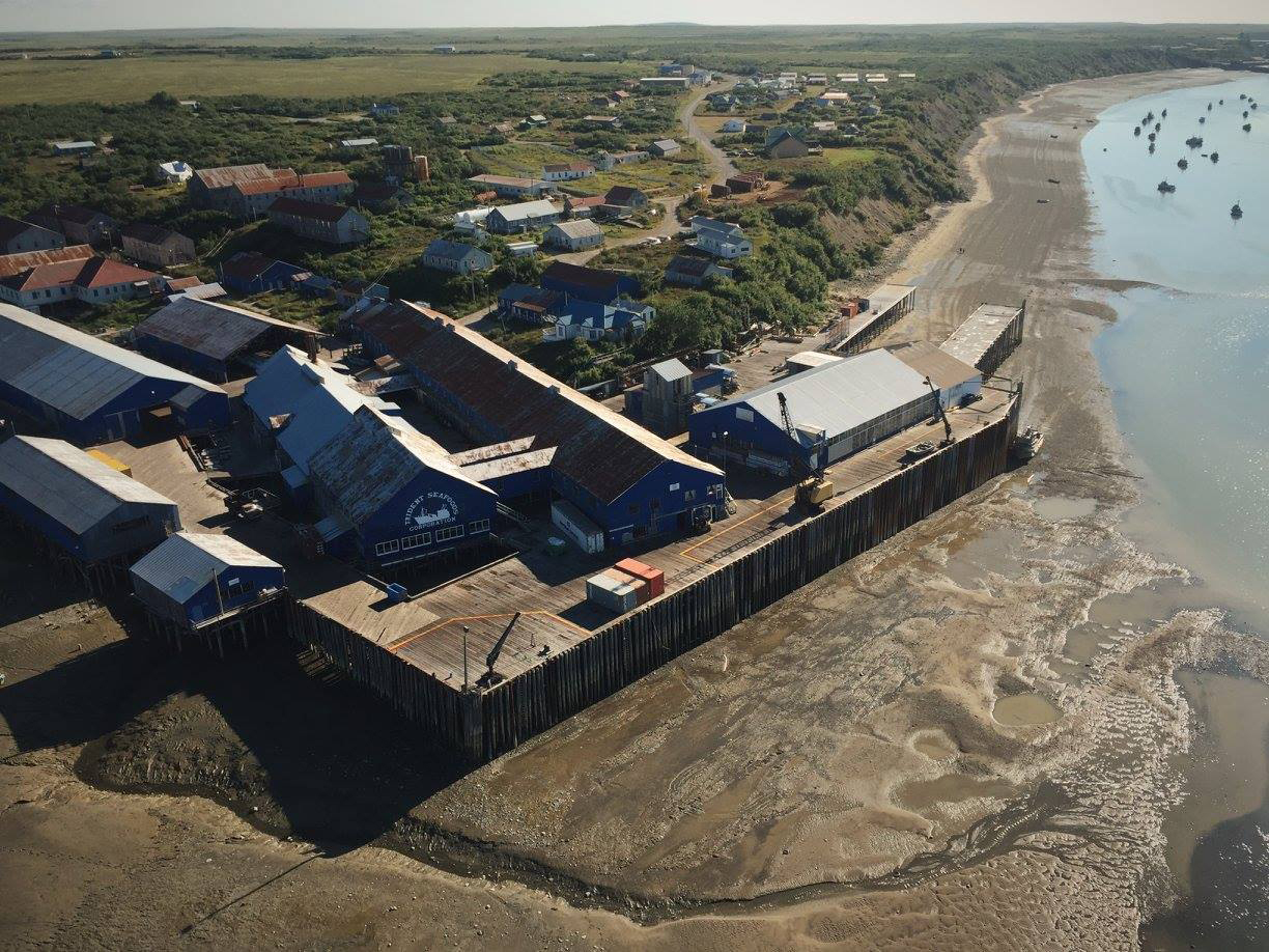
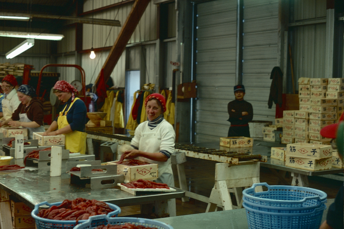
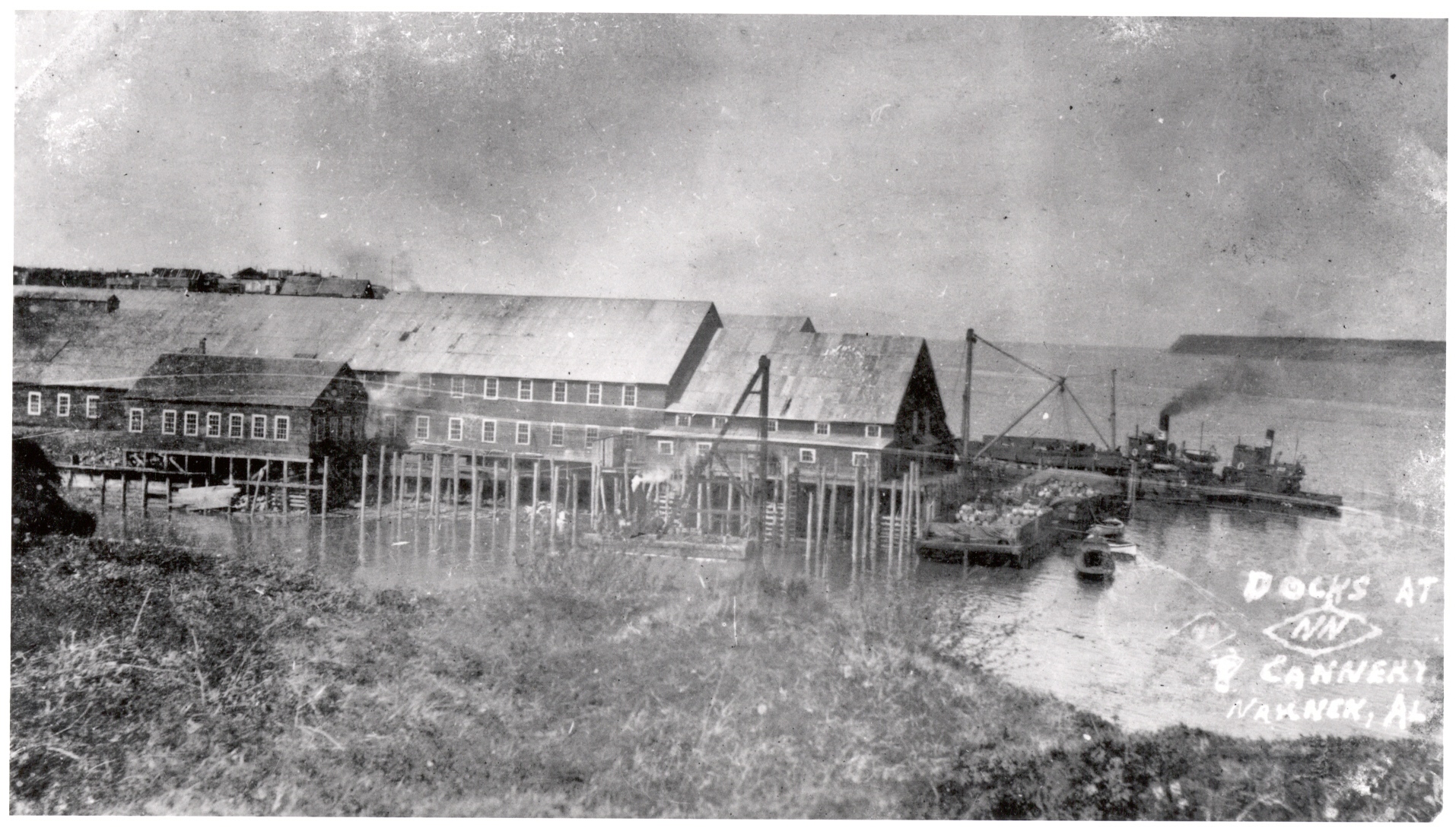
The NN Cannery looking southwest. Photo credit: Anne Pollnow, 2017, courtesy of Katherine Ringsmuth.
In August 2021, the Keeper of the National Register of Historic Places listed the Diamond NN Cannery Maritime Historic District, recognizing the historic salmon cannery's contribution to Alaska, national, and Pacific World history. The San Francisco-based Arctic Packing Company built the Diamond NN on the south shore of the Naknek River, on the east side of Bristol Bay, in rural Southwest Alaska. Each year, salmon return to the Bay's pristine spawning streams, representing the world's largest red salmon (sockeye) run. Canneries began to take advantage of the massive harvest in 1883 when the Arctic Packing Company established the first cannery on the Nushagak River.
The Arctic Packing Company later started the Diamond NN Cannery as a saltery in 1890, marking the first commercial fishing enterprise on the Naknek River. The company merged with over thirty rival Alaskan canneries three years later to form the new Alaska Packers Association (APA). The following year, in 1894, APA converted the Diamond NN into a salmon cannery. But until the 1920s, the company continued using the saltery for supplemental income. Except for two years during World War II, the cannery operated every summer, even outlasting APA, which dissolved in 1982.
A 50:1 scale map of APA's Diamond NN Cannery from March 15, 1968. Photo credit: Trident Seafoods.
By the end of the 20th century, the Diamond NN had processed millions of salmon and remained one of Alaska's oldest running canneries. In 1995, the American seafood giant, Trident Seafoods, bought the cannery and, after pulling canning lines in 2001, used the property as a support base for its other facilities nearby. In 2015, Trident officially closed the Diamond NN to fishermen. The company now uses the cannery solely for limited support services.
During its years of operation in remote South Naknek, the Diamond NN Cannery housed an international community to process a product sent to global markets. Over 130 years later, the buildings they used still stand, are in good condition, and hold the multifaceted and oft' forgotten history of a storied workscape.
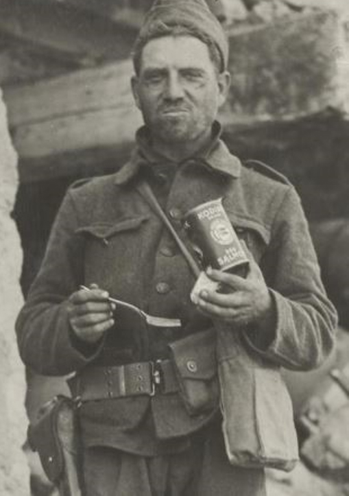
Recipes from APA's Argo Red Salmon Cookbook. How to Eat Canned Salmon. APA introduced the Argo brand and published the cookbook for the St. Louis World's Fair in 1904. A WWI soldier eating canned salmon. Photo credit: the Alaska State Museum.Canned salmon labels featured images of Alaska's exotic wilderness to attract customers in the late 19th century.
The APA's 1904 World's Fair display in St. Louis. Photo credit: The NN Cannery History Project.
While fish has fed humans since time immemorial, APA's canned salmon was not commonly consumed in early 20th century diets. In fact, APA had to 'teach' Americans how to eat canned salmon. The company participated in the 1900 World's Fair in Paris, and the 1904 fair in St. Louis. They created elaborate exhibits with interactive fishing and canning gear that engaged visitors. Canners capitalized on the rise of nation-wide advertising – even publishing salmon cookbooks – to entice potential canned salmon consumers. But the earliest form of canned salmon promotion was the label itself, which evoked the idea of easy, delicious meals made with fresh, exotic, wild Alaskan fish.
APA's efforts paid off. Canned salmon advertisements increasingly appeared in popular magazines, cookbooks, and public health advice, with tinned fish even feeding the frontline soldiers of World War I and II. Meanwhile, APA controlled 90% of Alaskan canneries, which were responsible for 70% of the territory's product. After statehood, the once bountiful salmon runs crashed, bottoming out in the early 1970s. However, after U.S. and Japanese import-export relations improved by the mid-1960s, canners added egg houses to process and sell salmon roe to Japan. Roe exportation became the industry's most lucrative product, saving Alaska's canned salmon trade.
The Crew
To produce the salmon pack, APA recruited an international workforce. Technology, laws, wars, racism, and rights all contributed to who worked there and when.
In the cannery's earlier years, fishermen working for the Diamond NN often came from Scandinavia, Italy, and Greece. Initially, company officials viewed the Scandinavians as the "superior" white fishermen. But former Diamond NN employees fondly remembered the garlic, olive oil, bread, and seafood feasts the Italians hosted, bringing a taste for Mediterranean foods to remote Alaska.
Alaska Native residents partnered with the Diamond NN cannery from its beginning until its closure. After the Spanish Influenza of 1919 decimated traditional communities, many indigenous people turned to cannery jobs. They acted as fishermen, the winter watchman, and the spring and fall crew. These crews worked the quiet months opening the cannery and winterizing the buildings after the busy season. The Cannery Caretakers (short documentary)
The current state of the Diamond NN's "Chinatown." Some of the buildings are not safe to enter but are all still standing. Photo credit: Katherine Ringsmuth, 2016.
At the cannery's start, the processing crew members were overwhelmingly Chinese. They lived in a separate section of the cannery grounds called "Chinatown." They were very skilled and earned a good reputation for their butchering abilities. But a butchering machine, at the time unapologetically patented as the "Iron Chink," eventually replaced them, while the Chinese Exclusion Act of 1882 further reduced their presence in the cannery.
The dominant culture of the processors changed with time. What had once been called the China Bunkhouse became the Mexican Bunkhouse by 1920, as Mexican workers originating in California joined the cannery crew in greater numbers after World War I.
African Americans also worked in the cannery, mostly from 1910-1920. But their contribution during production was eventually replaced and ignored as cannery labor began to unionize. The Southern market was not forgotten, however, where canners used racialized images on their labels to sell canned fish to African American and white consumers.
The former Filipino Mess Hall. After the canneries were desegregated in the 1970s, it became the Fishermen's Laundry. Photo credit: Katherine Ringsmuth, 2016.
After WWI, Filipinos dominated the cannery workforce and, through unionization, ended the corrupt labor contract system. Young Filipinos, aptly called the Alaskeros, worked to make money for college and took advantage of American social and economic opportunities. But despite their education, they still experienced segregated mess halls and living quarters. Using the American legal system, Filipinos fought for equal rights and cannery desegregation and won.
Women in the Egg House, packaging roe for sale in Japan in 1978. In the background, a Japanese technician checks for quality. Photo credit: Tom Connelly, courtesy of Katherine Ringsmuth.
While Japanese processors worked at the Diamond NN from the start, they gained new status after WWII. As the U.S. lifted import-export bans from the former enemy-turned-ally, APA sold the previously discarded salmon roe to Japanese buyers. These companies employed skilled Japanese technicians who ensured quality control for the roe shipped abroad. Operating in the cannery Egg House, the Japanese often preferred female workers to handle to delicate roe. This, combined with the passage of the Equal Opportunity Act of 1972, allowed more women to join the Diamond NN's ranks.
The cannery depended on an international mix of cultures to catch and can millions of salmon. The cannery's bunkhouses, mess halls, laundry, bakery, and other buildings housed a diverse work force, who fed, cleaned, and cooked for the cannery. Unlike other cannery buildings which have collapsed with age, many of the NN Cannery structures are still standing, some a century old. They contain the rich stories of these historically underrepresented yet economically vital laborers.
The Tangible Evidence
Over the past 130 years, the cannery buildings remained in place, withstood the weather, and avoided vandalism, including fire. Today, the 50 historic buildings, seven sites, two structures, and two objects constituting the Diamond NN Cannery Maritime Historic District convey the original layout. Former workers and local residents can still follow the boardwalks connecting the bunkhouses to the mess hall, the docks, and back.
Pictures of the cannery in 2017 and the early 1900s. Photo credit: Katherine Ringsmuth; Center for Pacific Northwest Studies, Western Libraries Heritage Resources, Western Washington University.
The Diamond NN Cannery represented the Industrial Revolution as it transformed Alaska. The industrial property retained an international crew, employed steam-driven machinery, and mass-produced canned salmon for over a century. When the cannery closed, the workscape no longer functioned in its historical role. But the original buildings' historical design and materials are still visible: the wooden floors, tin roofs, and siding, even the graffiti scribbled by anonymous authors. Today, the same smells remain: the odors of fish, oil, grease, saltwater, and the bakery remind visitors (new and returning) of the busy operation that once existed there. Despite deterioration, the buildings and surrounding landscape remain largely unchanged since the cannery's construction, presenting the same view seen by a century of workers. Importantly, they reveal 100 years of the canned salmon industry's history and its underrepresented participants.
"I was here" graffiti by Frank Russo, Theadore Cruise, and others. Photo credit: NN Cannery History Project.A carving of the Croatian flag sits on a tabletop. Photo credit: NN Cannery History Project. In the Fishermen's Bunkhouse. Photo credit: NN Cannery History Project.
The structures contain evidence of the superintendent, the Chinese and Mexican processors, the Filipino Union leaders, the Sugpiat set netters, the Italian fishermen, and the laundry ladies from the local village, who lived and worked there – for a few months, or even decades. Once-busy rooms preserve long-forgotten personal gear, lockers, fish bins, and boilers. Carved names on tabletops, flags on windows, and images of girlfriends back home offer a glimpse into the lives of the diverse workforce, who often left few other records about daily life at the cannery. Mug Up - Historic Cannery Footage
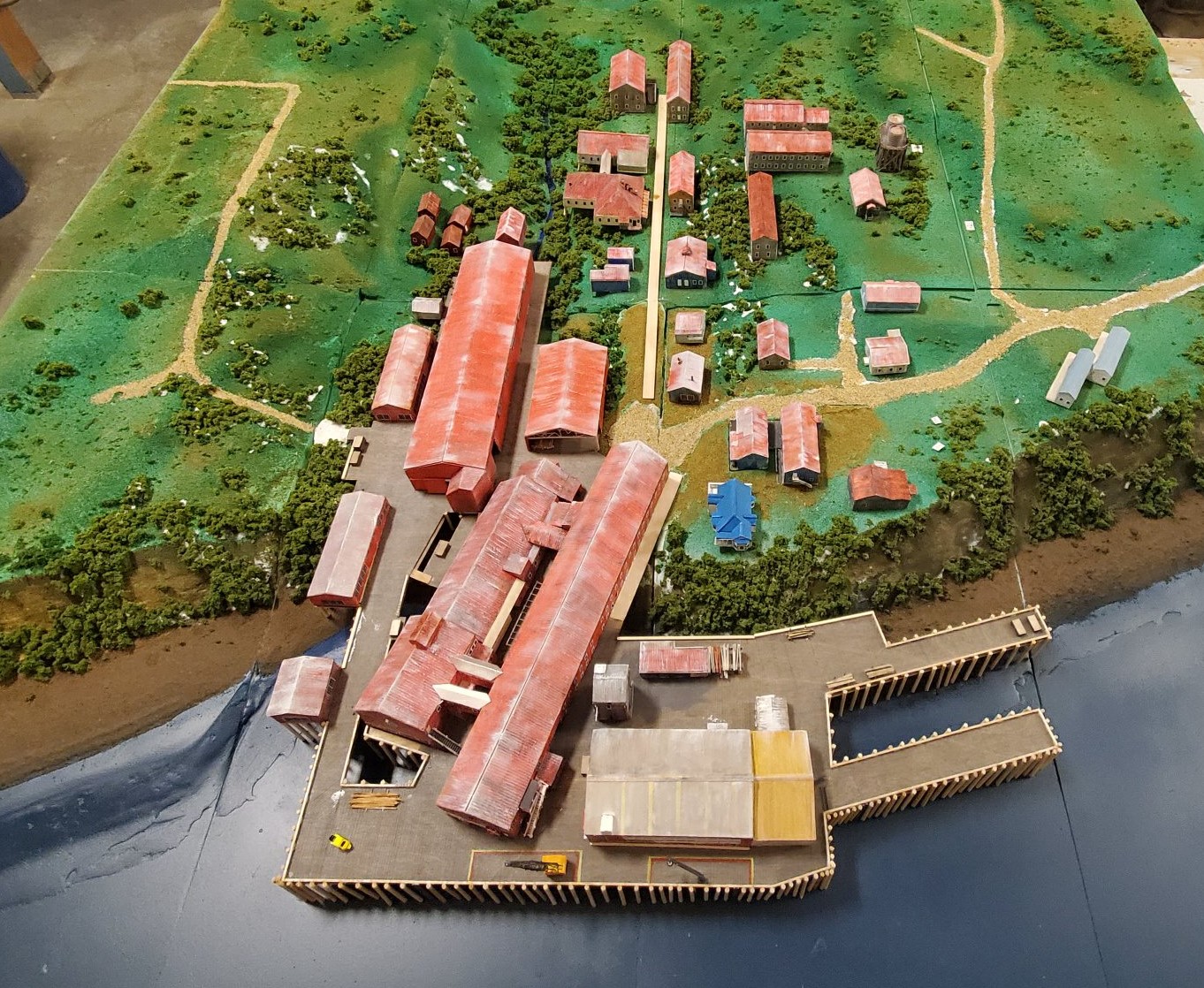
Members of the NN Cannery History Project, including Katie Ringsmuth and Bob King. Photo credit: Katie RingsmuthBob King interviewing Gary Johnson, a former Diamond NN superintendent, 2017. Photo credit: NN Cannery History Project A Bristol Bay High School student interviewed Natty Boskoffsky for the Digital Storytelling Workshop headed by Naknek artist Larece Egli. Photo credit: NN Cannery History Project The Bunkhouse and Mess Hall exhibits from the Mug-Up Exhibition at the Alaska State Museum. Photo credit: Alaska State MuseumSpring-Fall Crew displays from the Mug-Up Exhibition at the Alaska State Museum. Photo credit: Alaska State MuseumScale model of the Diamond NN Cannery by Alaskan artist Andrew Abyo. Photo credit: NN Cannery History Project
Canneries, like the Diamond NN, were designed with a functional, economical style. One feature included building the cannery over the water with gapped floorboards. This allowed rising tides to force cool air over the hot, fresh cans of fish. Photo credit: Center for Pacific Northwest Studies, Western Libraries Heritage Resources, Western Washington University.
After seven years of hard work, combining community enthusiasm and professional expertise, the NN Cannery was listed on the National Register in August 2021. The listing marked the first cannery in Bristol Bay to receive national recognition. Hopefully, it will not be the last.
For an in-depth history of the Diamond NN Cannery, visit The NN Cannery History Project's website. You can watch student and professional films and access articles, oral histories, and other media from there. APA and the Diamond NN also dealt with the deadly 1919 Spanish Influenza, sending medical aid to villages and caring for Alaska Native orphans. The NN Cannery History Project researched those events and their ripple effects in Bristol Bay. Resources are highlighted below:
About the Author:
Ava Martin is an intern at the Office of History and Archaeology. She enjoys sharing history's relevance and is finishing her senior year at the University of Alaska Anchorage, where she studies history and anthropology.
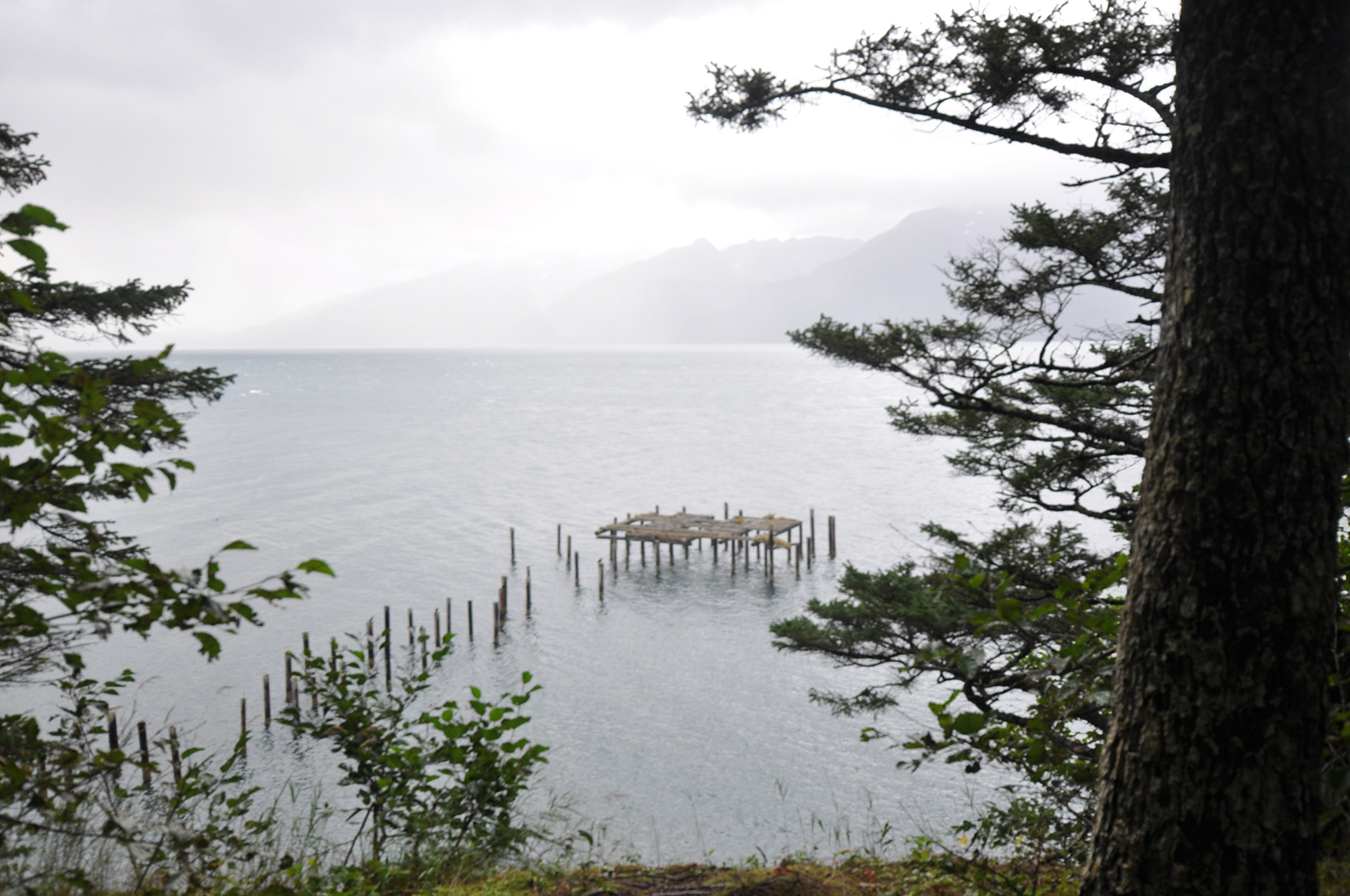
Gun Mount at Rocky Point looking over Resurrection Bay, September 2021
From September 8 to 14, a team of archeologists and architectural historians from the Office of History and Archeology surveyed Fort McGilvray, a coastal defense post from World War II, located approximately seven miles from Seward, Alaska. With assistance from State Park rangers, the investigation culminated in the nomination of Fort McGilvray Historic District to the National Register of Historic Places.
OHA Survey Team arrives at North Beach, September 2021 Towering cliffs of Caines Head rise sharply from Resurrection Bay at North Beach. September 2021
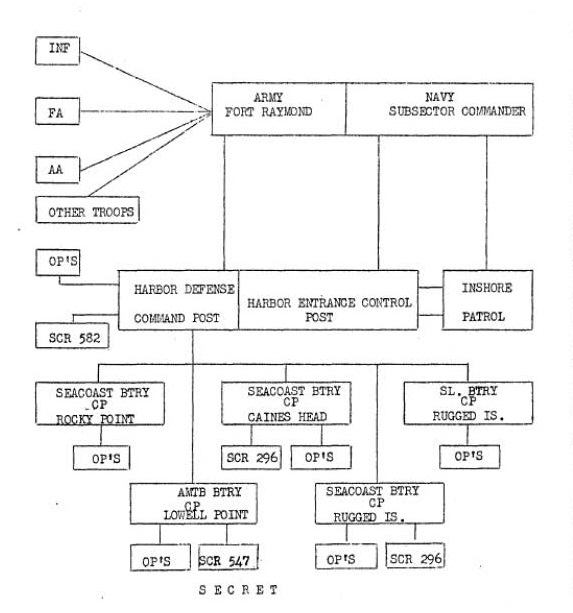
A diagram showing the organization outlined in General Order No. 105, Headquarters Alaska Defense Command, June 29, 1943, In "Supplement to the Harbor Defense Project Harbor Defense of Seward, September 9, 1947," in files of Alaska Office of History and Archaeology.Built from 1941 to 1944 atop towing cliffs rising from the west side of Resurrection Bay, Fort McGilvray was part of the extensive Seward Fixed Harbor Defense System constructed to protect the port of Seward, the terminus of the Alaska Railroad, and central access point into the Interior of Alaska.
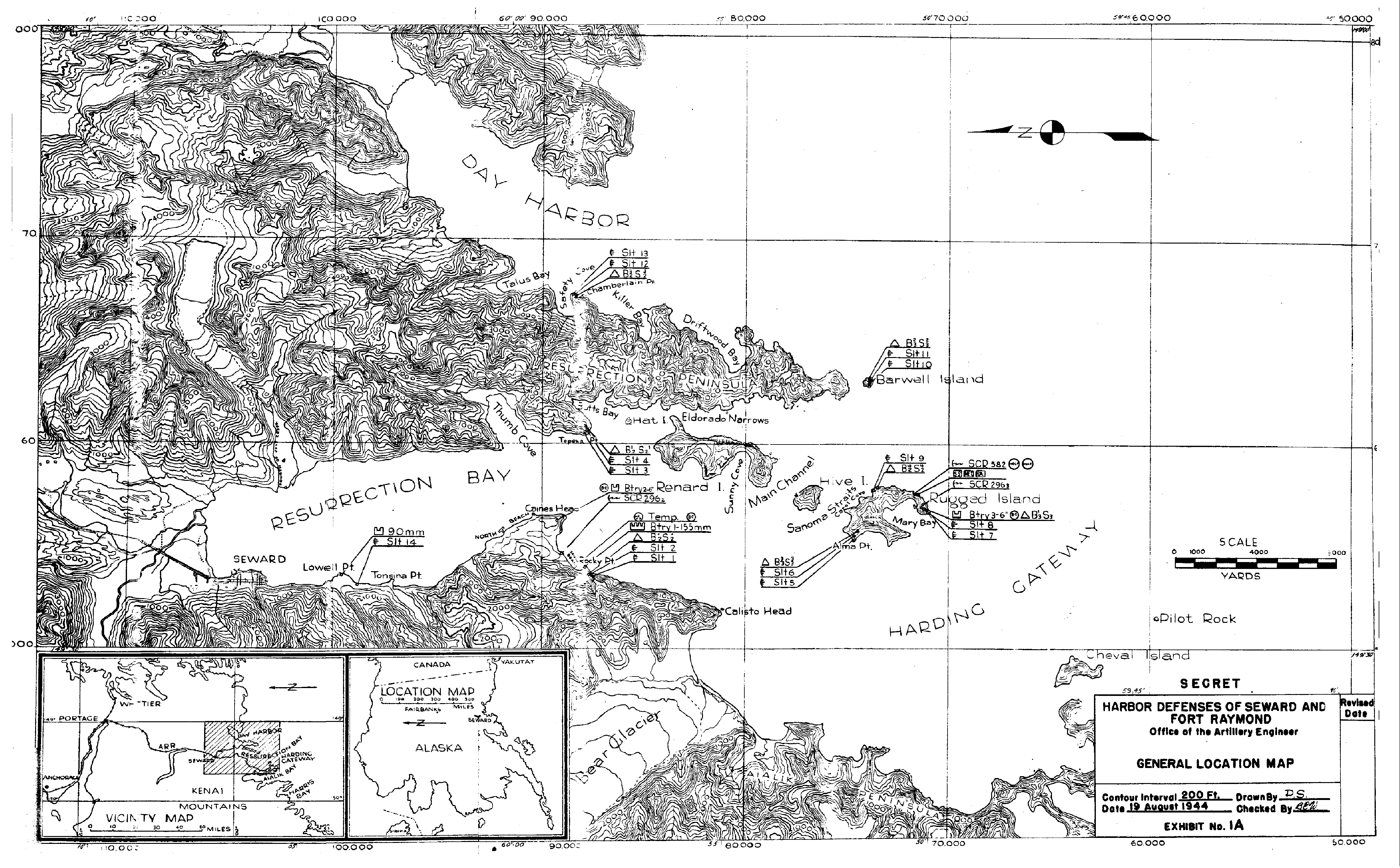
Harbor Defenses of Seward and Fort Raymond, General Location Map, 1944. U.S. Army Corps of Engineers.
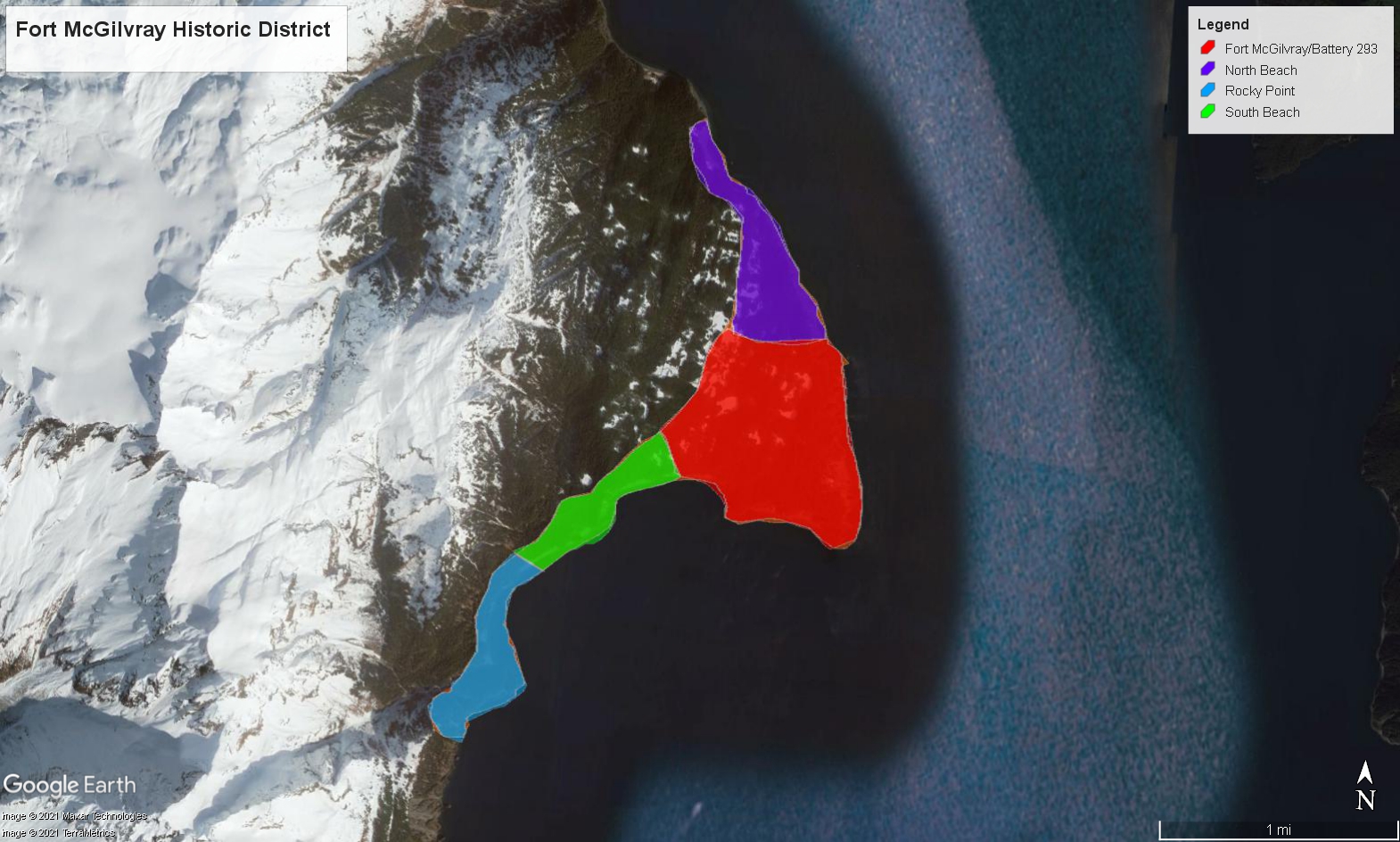
Encompassing roughly 700 acres, Fort McGilvray Historic District consists of four distinct geographical areas used for defense, command, and supply.
The distinct colors show the four separate areas that constitute the McGilvray Historic District. Map created by OHA staff.
Construction at Caines Head and South Beach started on July 31, 1941. In March 1943, the military named the installation Fort McGilvray after an Army Officer who commanded "Fort Kenay" in 1869. By March 1944, the military ordered the Fort dismantled after U.S. forces had driven enemy forces from the Aleutians and sent the guns to San Diego and South Dakota locations.
Remains of the six-inch gun mount at Fort McGilvray creates a sense of place allowing visitors to envision and better understand the defense of Alaska during World War II.
Established in 1971, the Caines Head State Recreational Area ( CHSRA) included 1800 acres. In 1974, the Park expanded by an additional 4000 acres. Until the 1964 earthquake, a road system originating at North Beach linked the four locales. State Parks began clearing the old military roads in 1984 to serve as the trail system for the Park. The historic North Beach Road, established by the U.S. military in 1941-1942, is similar to the historic Alcan Highway, for its role in the military supply chain and contribution to the War effort.
OHA staff walks along the historic road to Fort McGilvray, first built by the U.S. Army Corps of Engineers in 1941. Although once connecting Fort McGilvray's four distinct areas, the Army never built a road to connect Fort McGilvray to Fort Raymond in Seward. September 2021
Today, the Fort's wood buildings and structures, including the Quonset and Pacific huts, are ruins. But extant features with distinguishing military characteristics still convey the historic function and engineering of the post.
The remains of the World War II-era dock at North Beach. September 2021
At North Beach are the remains of a wood dock. At South Beach, evidence exists of the main cantonment.
OHA staff documents one of the collapsed barracks at South Beach. September 2021
Panama mounts for 155mm guns remain at Rocky Point.
The Panama mount 155 guns at Rocky Point offer visitors a panorama view of Resurrection Bay. September 2021
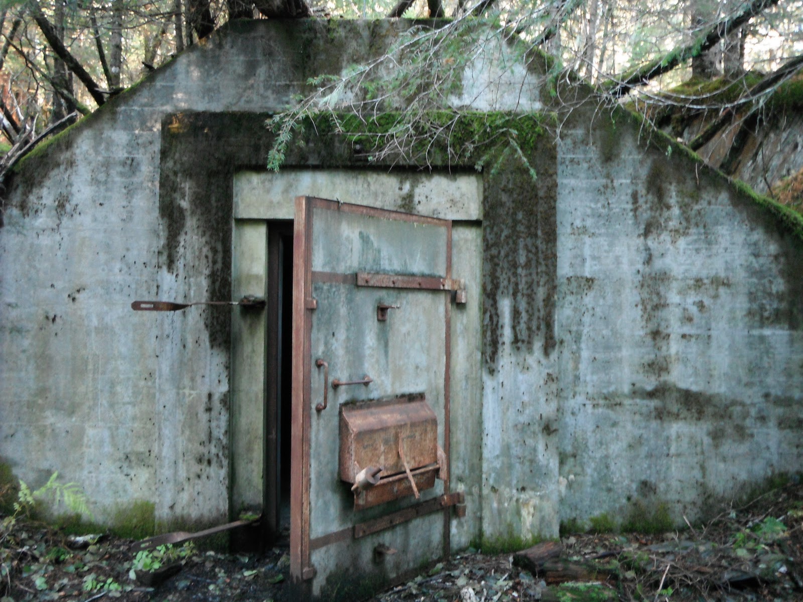
And, atop Caines Head Battery 293/Fort McGilvray, approximately 580 feet above the ocean, are several WWII-era remnants, including a fire control bunker, cement magazines, and Barbette mounts for two 6-inch guns.
Although many of Fort McGilvray's structures are dilapidated or in ruins, the Command Station is in excellent condition. It offers visitors a rare example of the Army's extraordinary engineering efforts during the War. September 2021 Entrance to the Comand Station at Rocky Point. September 2021
After 80 years, the concrete buildings and structures, including those at the main Battery, the ammunition magazines, gun mounts, and the hydroelectric dam, retain both architectural and historic integrity, and together, communicate to visitors an episode that profoundly changed Seward, the Territory of Alaska, and the nation—World War II.
The still-intact munitions bunkers are some of the best remaining representations of World War II activities at Caines Head and are popular visitor sites. September 2021.
The remains of a dam show how the U.S. Army Corps of Engineers modified and utilized the natural landscape at Caines Head. September 2021
A fire hydrant at South Beach is evident of the extraordinary infrastructure the Army installed to support its mission to protect Resurrection Bay. September 2021
Although most buildings are dilapidated or in ruins and much of the area is overgrown, the gun mounts, bunkers, and lookouts are intact and retain excellent integrity. Collectively, enough structures survive to communicate the immediacy and importance of the U.S. military's defense efforts in Alaska.
The overgrown vegetation made documenting the buildings at Fort McGilvray a challenge. September 2021
The OHA survey team carefully approaches the old barracks building near Battery 293 atop Caines Head. September 2021
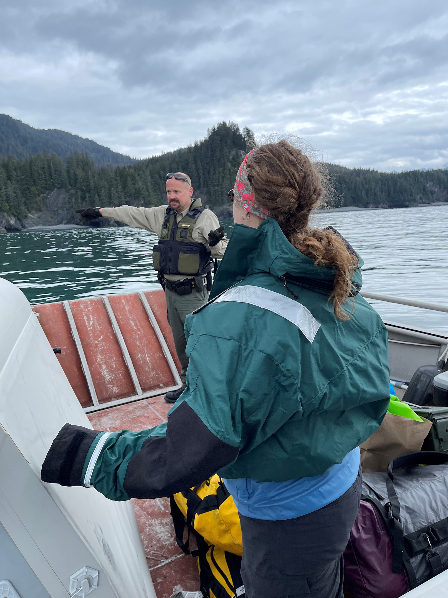
OHA team leader, Sarah Meitl, listens to Park Ranger Jack Ransom interpret the history and geography of Caines Head. September 2021
Because Fort McGilvray is now part of Caines Head State Recreation Area, it stands out for its exceptional interpretive value and ability to tell the history of the Coastal Defense System in Resurrection Bay and the lesser-known story of Seward's strategic role in the supply line from the Lower 48 to Interior Alaska. The collective features, reinforced by the environmental setting, convey the military's extraordinary engineering effort and defense activities at Fort McGilvray and allow visitors to experience World War II from the soldiers' perspective.
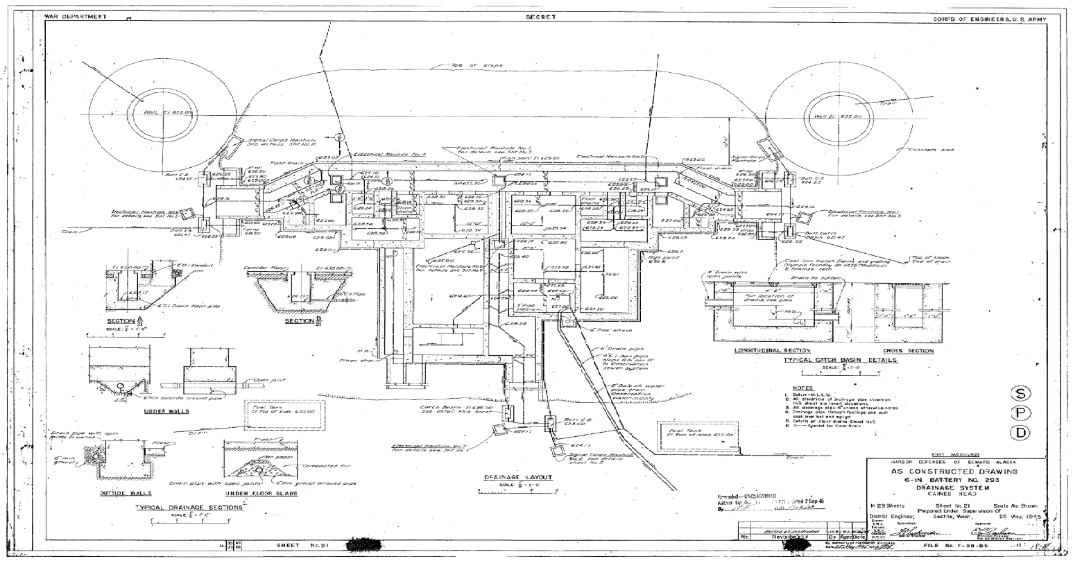
As-built drawing of Battery 293 and Drainage System illustrates the Army's engineering efforts at Caines Head. As Constructed Drawings U.S. Army Corps of Engineers, 1945
Today, Fort McGilvray Historic District resembles its historic appearance and retains significant design features and aspects of construction dating to WWII. Importantly, it still holds the historical memory of the soldiers stationed there nearly eight decades ago, even if they can no longer share that history themselves.
A Chair in the Command Station offers visitors the opportunity to experience a soldier's perspective of World War II. September 2021
As one of the best-documented and most visited coastal defense installations in Alaska, Fort McGilvray can educate—even inspire—the public about the history of WWII in Alaska and has the power to immerse future generations in a wartime landscape.
OHA surveyor documents discarded artifacts on a rare sunny day. September 2021
On Wednesday, December 8, the Alaska Historical Commission, a nine-member citizen review board chaired by Lieutenant Governor Kevin Meyer, determined that Fort McGilvray Historic District qualifies for listing in the National Register of Historic Places. The commission considered Fort McGilvray historically significant under Criterion A for its association with the defense of Alaska during World War II on national, state, and local levels. Under Criterion C for its extraordinary engineering, as the area's extreme coastal environment presented the military with one of its most challenging construction tasks of the entire War. And finally, Fort McGilvray Historic District is significant under Criterion D for its potential to yield additional information about military life at Caines Head during World War II.
As Build Plot Plat for Battery 293, 1945. U.S. Army Corps of Engineers
For a fascinating look at Fort McGilvray's construction history, check out this 26-minute historic film, U.S. Army Corps of Engineers Wold War II Army Moving Image Collection: Resurrection Bay & Whittier, from the Alaska State Library Historical Collections (ASL-AV014-09).
-Katherine Ringsmuth, PhD
State Historian/Deputy SHPO
About the Author:
Dr. Katherine Ringsmuth is the Alaska State Historian and Deputy State Historic Preservation Officer. In her spare time, she is running, skiing, or on a soccer or baseball field with her husband Eric, cheering on their two boys, Ben and Tom.
On Tuesday, May 25, 2021, the Alaska Historical Commission, a nine-member citizen review board chaired by Lieutenant Governor Kevin Myers, determined that Qinuyung, an ancestral Yup'ik village site located in southwest Alaska, qualified for listing in the National Register of Historic Places. Three months later, Qinuyang joined more than eighty-eight thousand other important historic properties in the nation's catalog of its significant cultural and historic history resources when the Keeper of the National Register of Historic Places added the site to the list on August 27, 2021.
Qinuyang about 5 years before the Spanish influenza epidemic hit in 1919. Photographed by Georege A. Parks. Alaska State Library
LiDAR image of Qinuyang. Note that the sod houses, Men's house, and other features are near the edge of the terrace, while the Russian Orthodox chapel remains (shaped like a square with a dot in the middle near the top of the image) is separated from the village. Courtesy of Monty Rogers.
The village of Qinuyang in 1962. Photographer Joan B. Townsend. Anchorage Museum Test Pit at Qinuyang. Courtesy of Monty Rogers.
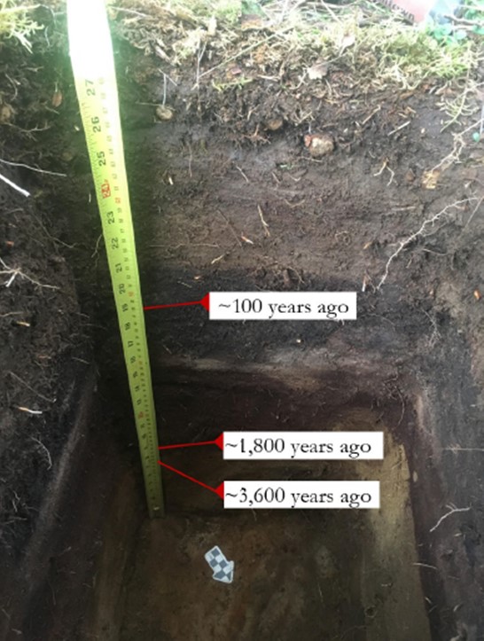
Situated on a wooded terrace overlooking the Kvichak River are the ruins of a once vibrant village, which consisted of single and multi-roomed winter houses, a qashgiq or men's house, small storage pits, a Russian Orthodox chapel with cemetery and fence, and a fish drying area. These historic remnants will inform archeologists about local subsistence patterns, resource use, food preservation, social relations, seasonality, and how residents dealt with aspects of colonialism. The ancient village is a regional time capsule, with buried evidence of human occupation going back 3600 years. "The site reflects a Kvichak River pattern of Yupiit people living in the same location as their ancestors of Norton and Arctic Small Tool traditions," wrote the nomination author, Monty Rogers. It is significant for its potential to provide important information about the Yupiit, including the Norton and Arctic Small Tool people's use of the Kvichak River."
"Qinuyung is a historical treasure, deserving of the National Register," said Igiugig resident AlexAnna Salmon, who testified at the meeting on behalf of the Igiugig Native Corporation and the Igiugig Village Council—both of which played central roles in the nomination process.
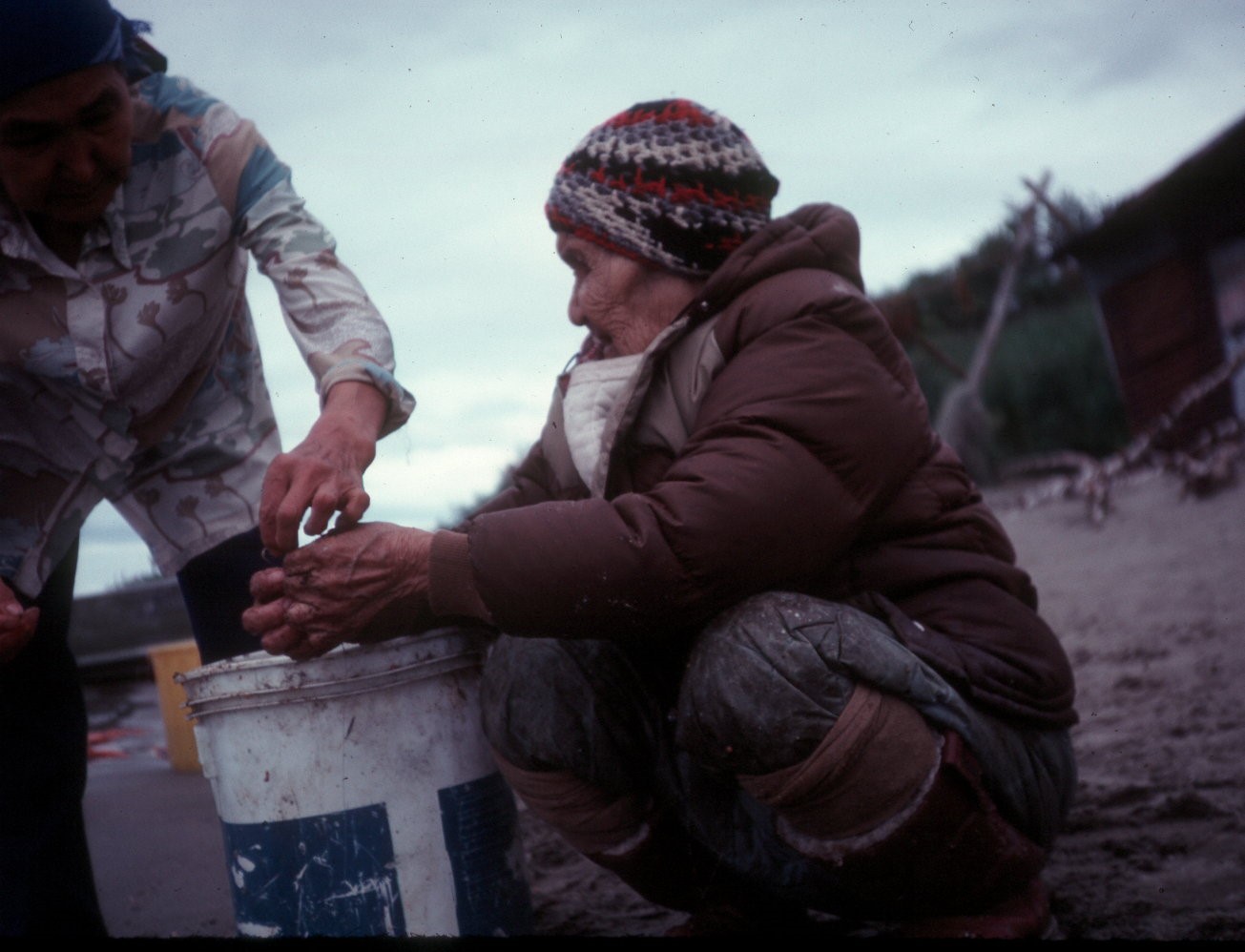
Anuska "Blind Grandma" Kasylie at fish camp. Courtesy of the NN Cannery History Project.
According to Salmon, the Qinuyung National Register nomination is part of a broader effort to 1) reclaim Igiugig's ancient history, 2) revive cultural heritage, 3) document archeological sites of the upper Kvichak River, and 4) engage youth and multi-generational residents in the processes to strengthen the community by creating continuity with the past.
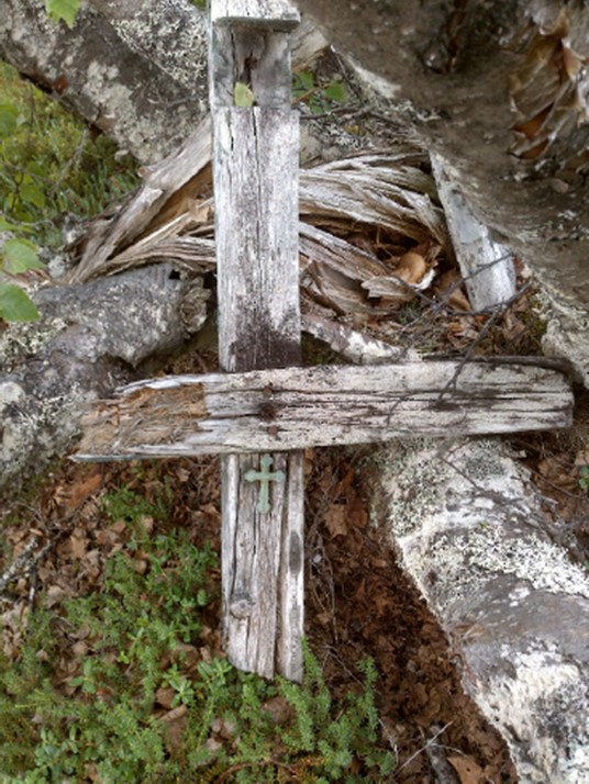
Cross from the graveyard. Courtesy of Monty Rogers.
Besides yielding archeological information, Qinuyang is significant for its association with the Spanish influenza pandemic of 1919, a seminal event in Bristol Bay that triggered its rapid demise. Equally important is Qinuyang's association with Anuska "Blind Grandma" Kasylie, a village resident who courageously led the few surviving children of the pandemic to safety. Because of her undaunted bravery and many other acts of kindness, today's residents of Igiugig, the Kvichak River, and Bristol Bay consider her a local hero.
Igiugig elder examining a tea kettle that she found near her in the remains of a sod house. Photographer AlexAnna Salmon. Courtesy of Monty Rogers.
Traumatic memories of the horrific events of 1919 caused residents to avoid Qinuyung for decades after the pandemic. Throughout the years, trees inhabited the area, replacing the grassy village site. The elders of Igiugig view the environmental shift as a sign the village is free of the pain inflicted by the pandemic. They believe the ancestors buried there are finally able to rest, and the old village site has found peace. "This [historical] work has helped to provide healing from our traumatic past, offers us strength to face the Covid-19 pandemic, and brings bright hope for the future," said Salmon.
Monty Rogers gives Igiugig youth a lesson in archeology. Courtesy of AlexAnna Salmon.
The Alaska Historical Commission members unanimously voted that Quinuyang is historically significant on a local level and qualifies for listing in the National Register under Criterion A, for its association with the 1919 Spanish flu pandemic; Criterion B, for its association with Anuska "Blind Grandma" Kasylie; and Criterion D, for its potential to yield information about how, for at least 3,600 years, people of the Kvichak River employed strategies to survive, face adversity, and culturally endure.
Monty Rogers gives Igiugig youth a lesson in archeology. Courtesy of AlexAnna Salmon.
-Katherine Ringsmuth, PhD
About the Author:
Dr. Katherine Ringsmuth is the Alaska State Historian and Deputy State Historic Preservation Officer. In her spare time, she is running, skiing, or on a soccer or baseball field with her husband Eric, cheering on their two boys, Ben and Tom.
Mission Statement
"The Division of Parks and Outdoor Recreation provides outdoor recreation opportunities
and conserves and interprets natural, cultural, and historic resources for the use,
enjoyment, and welfare of the people."