Desperation
Desperation
0 land parcels are currently available for sale.
Location
Desperation is located approximately 25 miles northwest of Fairbanks off Old Murphy Dome Rd.
Access Details
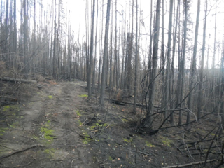
Access to the subdivision is from Old Murphy Dome Rd. to Desperation Loop. Desperation Loop is undeveloped and accessible by ATV, though the trail deteriorates further into the subdivision.
Utilities
There is no municipal water supply or sewer system. Please see plat notes and the “Sewer and Water” section of this brochure for details. There are no utilities (electric, phone, internet, etc.) currently in this area.
Local Government
Desperation is within the boundary of the Fairbanks North Star Borough and is subject to applicable platting authority, local ordinances and property assessments. Local ordinances may impose setbacks, easements, or restrictions in addition to those mentioned under “Restrictions” below. Please check with the borough for details of current ordinances.
Desperation subdivision is zoned Rural Estate (RE-4) by the Fairbanks North Star Borough. Use of these parcels is restricted by the zoning. Please contact the borough for details.
Fire
This area is in the Full Fire Management Option. See the “Wildland Fires and Burn Permits” section of this brochure for details.
Notes
A large portion of the subdivision burned in the 2019 Shovel Creek Fire. All of the parcels in this offering were affected by the fire.
Parcels within this subdivision may contain wetlands and may require a U.S. Army Corps or Engineers permit prior to the placement of fill material into these areas. Contact should be made prior to commencing construction.
Utility companies have the right to cross streets, buffer strips, reserve areas, and special interest areas or construct supportive devices within such lots or tracts as necessary to serve ASLS 81-1 and adjacent properties.
Restrictions
Easements affecting these parcels, as depicted on the plat, may include, but are not limited to, utility easements. Information on restrictions, easements, reservations, and setbacks may be depicted on the plat, contained in the plat notes, or be recorded separately.
Survey and Appraisal
Desperation is survey ASLS 81-1, located in Sections 29 and 32, Township 2 North, Range 3 West, Fairbanks Meridian.The survey has been filed as plat 82-17 in the Fairbanks Recording District.
Right-of-way Status
Desperation Loop is undeveloped.

