
Mount Rich Addition II RRCS
Mount Rich Addition II RRCS
6 land parcels are currently available for sale.

Parcel 498 - 1062
Region:
Southcentral
Subdivision: Mount Rich Addition II RRCS
Case File: ADL 234783
Brochure Pages PDF
Subdivision: Mount Rich Addition II RRCS
Case File: ADL 234783
Brochure Pages PDF
Acres: 17.42
No Road Access
Tract: A
Parcel 498 - 1063
Region:
Southcentral
Subdivision: Mount Rich Addition II RRCS
Case File: ADL 234784
Brochure Pages PDF
Subdivision: Mount Rich Addition II RRCS
Case File: ADL 234784
Brochure Pages PDF
Acres: 15.76
No Road Access
Tract: B
Parcel 498 - 1064
Region:
Southcentral
Subdivision: Mount Rich Addition II RRCS
Case File: ADL 234785
Brochure Pages PDF
Subdivision: Mount Rich Addition II RRCS
Case File: ADL 234785
Brochure Pages PDF
Acres: 15.76
No Road Access
Tract: N
Parcel 498 - 1065
Region:
Southcentral
Subdivision: Mount Rich Addition II RRCS
Case File: ADL 234786
Brochure Pages PDF
Subdivision: Mount Rich Addition II RRCS
Case File: ADL 234786
Brochure Pages PDF
Acres: 16.67
No Road Access
Tract: O
Parcel 498 - 1066
Region:
Southcentral
Subdivision: Mount Rich Addition II RRCS
Case File: ADL 234787
Brochure Pages PDF
Subdivision: Mount Rich Addition II RRCS
Case File: ADL 234787
Brochure Pages PDF
Acres: 16.18
No Road Access
Tract: R
Parcel 498 - 1067
Region:
Southcentral
Subdivision: Mount Rich Addition II RRCS
Case File: ADL 234788
Brochure Pages PDF
Subdivision: Mount Rich Addition II RRCS
Case File: ADL 234788
Brochure Pages PDF
Acres: 15.92
No Road Access
Tract: S
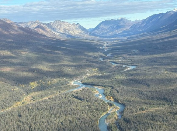
Location
Mount Rich Addition II RRCS is located approximately 125 air miles northwest of Anchorage and approximately 69 air miles west of Skwentna, along the confluence of the South Fork of the Kuskokwim and Hartman rivers.
Access Details
Primary access to the area is by plane to gravel bars along the South Fork of the Kuskokwim River.
The rivers are unsuitable for landing and take-off due to river currents and sand bars. Snowmachine access is possible in winter.
Utilities
There is no municipal water supply or sewer system. Please see plat notes and the Sewer and Water section of this brochure for details. There are no utilities (electric, phone, internet, etc.) currently in this area.
Local Government
This area is not within the boundaries of an organized borough. It is located within the Unorganized Borough and is subject to the State of Alaska platting authority.
Fire
This area is in the Limited Fire Management Option. See the Wildland Fires and Burn Permits section of this brochure for details.
Notes
These parcels may contain wetlands. Purchasers must obtain permits from the U.S. Army Corps of Engineers before developing any wetland areas.
The Puntilla Lake to Rohn connector trail of the Iditarod National Historic Trail runs along the South Fork of the Kuskokwim River through the area. This trail is utilized by Iron Dog snowmobile race and the Iditarod Trail Invitational ultramarathon when conditions permit.
Restrictions
Easements affecting these parcels, as depicted on the plat, may include, but are not limited to, public access & utility easements. Information on restrictions, easements, reservations, and setbacks may be depicted on the plat, contained in the plat notes, or recorded separately. All parcels have 30ft public access/utility easements along all lot lines. Parcel 1065 (Tract O) is bisected by a 50ft section line easement. See plat for details.
Survey and Appraisal
Mount Rich Addition II RRCS is survey ASLS 2023-05, located in Sections 4, 28, 32, & 33, Township 22 North, Range 22 West, Seward Meridian. The survey has been recorded as Plat 2025-2 in the Mount McKinley Recording District.