Nenana-Totchaket Subdivision, Phase 1A
Nenana-Totchaket Subdivision, Phase 1A
0 land parcels are currently available for sale.
Attention
The sale of agricultural interest is the conveyance of the land estate and subject to conditions and covenants relating to agricultural use and development. The required covenants are:
1. A perpetual covenant for the benefit of Alaska residents and running with the land that restricts of limits the use of the land for agricultural purposes; and
2. A perpetual covenant that permits the owner of the land, obtained under this contract, to subdivide and convey not more than four parcels of the land of not less than 40 acres each, subject to the restriction that a subdivided
parcel may not be further subdivided and further subject to the limitations established within AS 38.05.321(e).
Agricultural Purposes are defined in statute as:
1. The production, for commercial or personal use, of useful plants and animals;
2. The construction of: housing for landowners and farm laborer's, improvements for animals, improvements that are reasonable required for or related to agricultural uses;
3. The use of gravel reasonably required or related to agricultural production on the parcel conveyed; and
4. Removal of and disposition of timber in order to bring agricultural land into use.
Location
The Nenana-Totchaket Phase 1A area is located within the DNR’s Northern Region, approximately 5 miles west of Nenana.
Access Details
Access to the project area is via Totchaket Road, a right-of-way easement ADL 409501, 500-feet in width extending approximately 29-miles with 12 miles developed from the Nenana River bridge through the project area. The Rights-of Way for Moe’s Road, Rush Road, Kohlrabi Court, and a portion of Totchaket Road are dedicated to the public by plat 2022-1. Access ranges from developed gravel roads to off-road vehicle trails. See brochure for details.
Utilities
There are no known services that exist within or in the immediate vicinity of this project area. There are no waste disposal facilities within or in the immediate vicinity of this project area. All on site wastewater disposal systems must meet the regulatory requirements of the ADEC.
Local Government
This area is located in the Unorganized Borough and is subject to the State of Alaska platting authority.
Fire
This area is in a Modified Fire Management Option. See the "Fire and Burning Activities" section of this brochure for details.
Notes
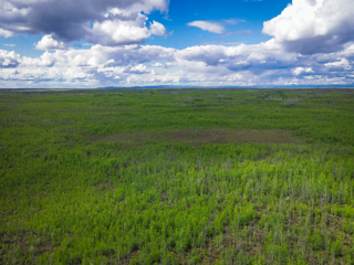
The landscape is generally level with rolling hills and scattered kettle ponds, consistent with the uplands of the surrounding region.
The low-lying areas that are wet with bogs and ponds have moss and short herbaceous plants; as the landscape rises and becomes more dry, mixed berries, willows, alders, and other small to medium woody plants can be found. In the areas described as “uplands”, a mix of early-mid growth and mature birch, spruce, and poplar are present.
Soils within this area generally consist of Nenana silt loam (42%) and similar other silt loams (collectively 85% of the overall soils) that are undulating, rolling, or nearly level. They are well drained with a depth to restrictive features of more than 80 inches. The profile pattern (85% of the overall soils) is as follows: the top few inches are decomposed plant material, mid-depth is typically silt loam, and additional silt loam and sand-silt at full depth. Approximately 77% of the soils in the project area are categorized as non-irrigated capability class IV. The soil is considered frost free for 80-120 days. Non-irrigated capability class IV soils are considered appropriate for agricultural development. However, the Natural Resources Conservation Service (NRCS) defines these soils as having severe limitations that reduce the choice of plants or that require very careful management, or both. A significant factor in the soil classification for agriculture development is the climate. Understanding that climate, in conjunction with plant choice and
soil class, will determine success in agriculture crop production. NRCS will be performing a more detailed soil report for the project area during 2021. The subsequent soil report will provide valuable information in the agriculture capability and design of offered parcels.
These parcels are being sold under the State’s Agricultural Land Disposal Program. Prospective buyers should, however, be aware that while these parcels do have soils suitable for growing crops, the elevation, aspect, presence or permafrost and other physical conditions may limit crop selection and/or require special management techniques in developing the agricultural potential.
Parcels within this subdivision may contain wetlands and may require a permit from the U.S. Army Corps of Engineers prior to the placement of fill materials into these areas.
Restrictions
Easements affecting these parcels, as depicted on the plat, may include, but are not limited to: section line, access, and utility easements. Information on restrictions, easements, reservations and setbacks may be depicted on the plat, contained in the plat notes, or be recorded separately.
Survey and Appraisal
Nenana-Totchaket Subdivision, Phase 1A is survey ASLS 2021-16, located in Sections 1, 2, 3, 11, and 12, Township 4 South, Range 9 West, Fairbanks Meridian. The survey has been filed as plat 2022-1 in the Nenana Recording District.

