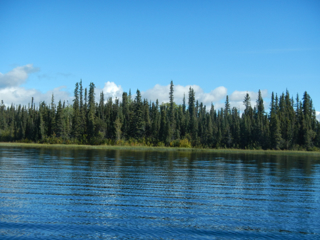
Parcel Detail

Parcel 496 - 1051
Acres: 4.71
No Road Access
Lot: 7
Case File
Veteran Discount
The State of Alaska offers qualified Alaska resident veterans a once-in-a-lifetime discount on the purchase of state land.
Estimated Veteran Price: $30,000.00
Location
All parcels are located on the northern half of Susitna Lake. Parcel 1054 is on the northeastern shore of Susitna Lake. All other parcels are on the northwestern shore. Access to the lake is from the Lake Louise boat launch.
Meridian Township Range Section (MTRS): C008N008W10
Access Details
All parcels are shore front and are accessible by boat, floatplane, or snowmachine from the boat launch on the south side of Lake Louise. The boat launch is accessible from Lake Louise Rd, approximately 16 miles north of the Glenn Hwy. Susitna Lake is adjoined to Lake Louise by a narrow and shallow channel. The parcels are approximately 12-15 miles north of the Lake Louise boat launch.
Utilities
There is no municipal water supply or sewer system. Please see plat notes and the Sewer and Water section of this brochure for details. There are no utilities (electric, phone, internet, etc.) currently in this area.
Local Government
This area is within the boundary of the Matanuska-Susitna Borough and is subject to applicable platting authority, local ordinances, and property assessments. Local ordinances may impose setbacks, easements, or restrictions in addition to those mentioned under Restrictions below. Please check with the borough for details. There is currently no zoning for the subdivision.
Fire
This area is in the Full Fire Management Option. See the Wildland Fires and Burn Permits section of this brochure for details.
Notes
These parcels may contain wetlands. Purchasers must obtain permits from the U.S. Army Corps of Engineers before developing any wetland areas.
Restrictions
Easements affecting these parcels, as depicted on the plat, may include, but are not limited to, public access and utility easements. Information on restrictions, easements, reservations, and setbacks may be depicted on the plat, contained in the plat notes, or be recorded separately. There is a 50ft public access easement and a 100ft building setback upland from ordinary high water of Susitna Lake. Parcels have 15ft utility easements around various lot lines. Parcels 1051 & 1054 have a 20ft utility easement and 50ft public access easement along the south lot lines. Parcel 1058 has a 20ft utility easement and 50ft public access easement along the north lot line, as well as a 100ft public access easement that extends along approximately 60% of west lot line. Please see the easement vacation plats for details.
Survey and Appraisal
The Susitna Lake parcels are located in Sections 10, 13, 14, 22, 27, & 34, Township 8 North, Range 8 West, Copper River Meridian. The parcels are depicted on various US Surveys and associated DNR Easement Vacation Plats. See attached surveys for details.
Parcel Maps
View parcel with
Alaska Mapper Tool
Alaska Mapper User's Guide
