Parcel Detail
Attention - Residency Requirements
Only Alaska residents may submit bids in the Sealed-Bid Auction.

Parcel 496 - 1001
Acres: 3.3
No Road Access
Lot: 17
Case File
Veteran Discount
The State of Alaska offers qualified Alaska resident veterans a once-in-a-lifetime discount on the purchase of state land.
Estimated Veteran Price: $55,009.35
This veteran's price is based on the minimum bid. When placing your bid, you will be bidding a non-discounted price. The actual discounted price based on your bid will be calculated using the method detailed in the brochure, if you qualify for the program and win the parcel.
Why Buy
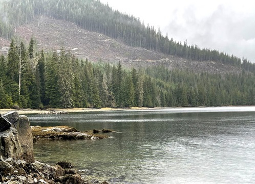
Clark Bay North parcels are ocean front lots on beautiful Prince of Wales Island.
Location
Clark Bay North is located near Hollis, on the east side of Prince of Wales Island on Twelvemile Arm, about 20 miles east of Klawock by road and about 35 miles west of Ketchikan by water. The parcel is located approximately 1.5 miles northeast of the Ferry Terminal in Hollis.
Meridian Township Range Section (MTRS): C073S048E25,26
Access Details
Access to the parcels is by boat, floatplane, or overland on foot along the shoreline or along undeveloped Nanny Bay Road. The state ferry landing at Hollis provides daily access to the Prince of Wales Island from Ketchikan. A state-owned seaplane base is available, and there is scheduled daily air service from Ketchikan to Klawock. The harbor in Hollis provides for boat moorage and launching.
Utilities
There is no municipal water supply or sewer system. Please see the Sewer and Water section of this brochure for details. There are no utilities (electricity, phone, internet, etc.) currently in this area. There is electric service on Nanny Bay Road, though it does not extend to this parcel.
Local Government
This area is not within the boundaries of an organized borough. It is located within the Unorganized Borough and is subject to the State of Alaska platting authority.
Fire
This area is in the Modified Fire Management Option. See the Wildland Fires and Burn Permits section of this brochure for details. Hollis Volunteer Fire Department provides fire protection and EMS services within the community of Hollis.
Notes
There is logging and forest management activity in the area. An area approximately 500ft west of the parcel has been logged in recent years. The Alaska Mental Health Trust has recently approved a timber sale (MHT 9101091) on lands north and west of the parcel. DNR’s Division of Forestry is
pursuing an easement for a log transfer facility in the general area (ADL 108788). The log transfer facility could be used to support commercial logging operations in the future. These parcels may contain wetlands. Purchasers must obtain permits from the U.S. Army Corps of Engineers before developing any wetland areas.
Restrictions
Easements affecting this parcel, as depicted on the plat, may include but are not limited to, utility and public access easements. Information on restrictions, easements, reservations, and setbacks may be depicted on the plat, contained in the plat notes, or recorded separately. The parcel has a 15ft public utility easement along the eastern land northern lot lines. There is a 50ft public access easement along the shoreline. There are restrictions on further subdividing this parcel, see plat note 7.
Survey and Appraisal
Clark Bay North is ASLS 2006-73, located in Sections 25 & 26, Township 73 South, Range 84 East, Copper River Meridian. The survey has been filed as Plat 2009-6 in the Ketchikan Recording District. Also see Section Line Easement Vacation Plat, DNR File No. EV-3-114. The plat has been recorded as
Plat 2010-18 in the Ketchikan Recording District.
Right-of-way Status
Nanny Bay Road is partially developed. The developed section of the road ends approximately a 0.5 miles before the parcel.
Parcel Maps
View parcel with
Alaska Mapper Tool
Alaska Mapper User's Guide