
Granite Mountain RRCS
Granite Mountain RRCS
0 land parcels are currently available for sale.
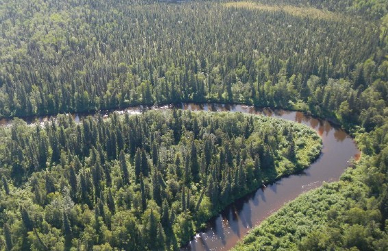
Location
Granite Mountain is located on the Kuskokwim River approximately 50 air miles southwest of McGrath and 38 air miles northeast of Stony River. The area covers a span of approximately 5.5 miles along the Kuskokwim River.
Access Details
Access is by river boat or snowmachine along the Kuskokwim River, or by bush/floatplane. The nearest airports are located at Stony River and McGrath. Air travel requires landing on either water or river gravel bars.
Local Government
This area is not within the boundaries of an organized borough. It is located within the Unorganized Borough and is subject to the State of Alaska platting authority.
Fire
This area is in the Full Fire Management Option. See the Wildland Fires and Burn Permits section of this brochure for details.
Notes
These parcels may contain wetlands. Purchasers must obtain permits from the U.S. Army Corps of Engineers before developing any wetland areas. Parcel 1053 was formerly a short-term RRCS lease. There are no known improvements on the property.
Restrictions
Easements affecting these parcels, as depicted on the plat, may include, but are not limited to, section line, utility, and public access easements. Information on restrictions, easements, reservations, and setbacks may be depicted on the plat, contained in the plat notes, or recorded separately. All parcels have 30ft public access and utility easement around all lot lines. Parcels 1054 & 1055 have a 50ft section line easement along the east lot lines. Parcels 1056 & 1057 have a 50ft section line easement along the south lot lines. Please see plat for details.
Survey and Appraisal
Granite Mountain is survey ASLS No. 2019-01, located in Sections 1, 16, 20, and 31, Townships 25 and 26 North, Ranges 37 and 38 West, Seward Meridian. The survey has been recorded as plat 2021-1 in the Kuskokwim recording district.
Right-of-way Status
None. Legal access is from the Kuskokwim and Nunsatuk Rivers, and overland across unreserved State-owned land.