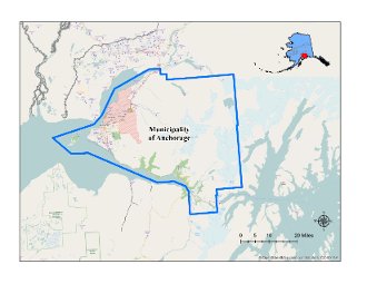
Municipality of Anchorage
Unified Home Rule Borough
2022 Population: 289,810
Size: 1,961 Square Miles
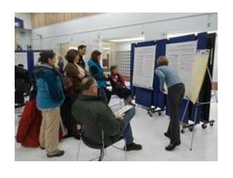
Historic Preservation Commission: The Historic Preservation Commission encourages and furthers the interests of historic preservation by identifying, protecting, and interpreting the Municipality's significant historic and cultural resources for the economic and social benefit of the community.
Date Certified: 1995
Meets: 4th Thursday of every month
Four Original Neighborhoods Interpretive Plan

-
CLG Grants

Survey and Inventory Grants
Fairview Historic Building Survey. 2005.
Mountain View Historic Building Survey. 2004.
Historic Building Inventory. 1996.National Register of Historic Places Grants
Army Housing- Pilots Row Block 13. 2015
Historic Preservation Development/Predevelopment Grants
Pioneer School Roof. 2011.
Historic Preservation Education Grants
Centennial Web Page. www.anchoragecentennial.org 2013.
Oscar Anderson House Brochure. 2012Commission Training Grants
National Alliance of Preservation Commissions Forum. 1997, 2008, 2014, 2015, 2017.
Local Historic Preservation Commission Training, National Trust for Historic Preservation Conference. 2013.
League of American Theaters: Financing Historic Rehabilitation Projects Seminar. 2005Historic Preservation Planning Grants
Anchorage Historic Preservation Plan, 2016.
-
A Brief History
-
Anchorage, today Alaska's largest city, had a Dena'ina fish camp at the mouth of Ship Creek in 1915, but the town was not the site of a fur trading post or founded as a gold rush town. The Dena'ina Athabascan people lived seasonally at several sites within today's municipal boundaries and hunted, fished, and traveled around the area for more than a thousand years before the outsiders arrived. Dena'ina history is becoming better known through oral traditions, language, and photographs, as well as through investigating archaeological sites such as Beluga Point. Several historic buildings at Eklutna., which became the Den'aina major year-round permanent village in the Anchorage area in the early 1900s, help tell their history as well.
In 1915, the federal Alaska Engineering Commission selected the mouth of Ship Creek for its main southern construction camp when building the Alaska Railroad between Seward and Fairbanks. The government platted the townsite, sold lots, and managed city affairs until 1920. Several houses, businesses, first school, and the wireless station remain from the town's first years. Fortuitously for Anchorage, the Alaska Railroad moved its administrative offices from Seward to the new town in 1918. Through the 1920s and 1930s the railroad was the principal employer. The railroad promoted homesteading adjacent to its track and had several section houses for track maintenance within today's Municipality of Anchorage boundaries.
In 1924, a year after the railroad was finished, Noel Wien took off in his airplane from the Anchorage Park Strip for Fairbanks, signaling the start of commercial aviation in Alaska. The Territory built an airstrip east of the Anchorage townsite, Merrill Field, in the late 1920s. As the city's initial public buildings needed to be enlarged and upgraded during the 1030s and 1040s, the replacements were built of concrete, including city hall, the federal building with the post office and courthouse, railroad depot and offices, and several schools. Commercial buildings in the town, too, began to be built with concrete, among them a radio station, theater, and hospital. Several federal New Deal programs to combat the Great Depression funded the construction of some of these buildings. The government also funded a new power plant north of town to serve both Anchorage and the government's Matanuska Colony resettlement colony in the Matanuska Valley. The colony project spurred construction of a road between the two communities, today the southern part of the Glenn Highway. Anchorage was becoming a transportation hub for the territory.
The U.S. military started building posts around Alaska in the late 1930s to defend the North Pacific. With its location in southcentral Alaska, Elmendorf Field and Fort Richardson were hastily constructed to facilitate supplying posts at Kodiak and on the Alaska Peninsula and Aleutian Islands. Activity intensified after the Japanese attacked Dutch Harbor in June 1942. World War II ended in 1945, but a new conflict, the Cold War, kept the military in Alaska. The Alaska Defense Command centers were at Elmendorf Air Force Base and Fort Richardson. Staff coordinated remote building programs around Alaska for communications, early warning, and defense, including four Nike Hercules missile sites around Anchorage.
The population of Alaska increased dramatically during and after World War II, primarily because of jobs available for the military construction projects. The workers needed professional services, stores, housing, medical facilities, and government services, and these attracted still more people to Anchorage. The first high rise buildings in Alaska were built in Anchorage in the early 1950s. A community college and a private college were founded. New and long-time residents campaigned for Alaska to become a state, finally succeeding in their efforts in 1959.
Statehood created more government jobs. Anchorage was the state's southcentral regional center, and the new State of Alaska opted to headquarter its natural resources department in the city. The state was selecting lands granted to it under the statehood act and leasing land for oil and gas and other mineral exploration. Alaska Natives settled their land claims with the federal government in 1971, and following the Prudhoe Bay oil discovery in 1968, oil companies and then the new Native corporations established corporate offices in Anchorage to be close to the federal and state land and permitting offices. The federal government expanded its presence in Alaska to transfer lands to the state and Alaska Natives and to administer federal lands, 60% of Alaska's land, particularly after the additions to federal conservation units were legislated in 1980.
A magnitude 9.2 earthquake on March 27, 1964, caused extensive damage to southcentral Alaska. Anchorage rebuilt, and its port and the railroad were critical to helping other damaged areas. The town expanded south and east, and new subdivisions were established. The State of Alaska created Chugach State Park on the outskirts of Anchorage in 1970. The City of Anchorage and Greater Anchorage Area Borough merged to form the Municipality of Anchorage in 1975, an area of over 1,700 square miles. Alaska's oil wealth financed a number of civic building projects in the municipality--roads, port and airport projects, and public buildings, the best known called the Project 80s program. Anchorage's population continued to grow, with many rural Alaskans relocating to the community for education, jobs, and services that were available. Today about 300,000 people—almost half the population of the state--live in the Anchorage municipality.
-
-
National Register of Historic Places Listings

A. E. C. Cottage No.23
618 Christensen Dr.
Alaska Engineering Commission Cottage No. 25
645 W. Third Ave.
Anchorage Cemetery
535 E. 9th Ave.
Anchorage City Hall
524 W. 4th Ave.
Anchorage Depot
411 W. First Ave.
Anchorage Hotel Annex
330 E St.
Oscar Anderson House
4th & D Sts.
Beluga Point Site
Address Restricted
Campus Center
Alaska Pacific University Dr.
Civil Works Residential Dwellings
786 and 800 Delaney St.
David, Leopold, House
605 W. Second Ave.
Eklutna Power Plant
Old Glenn Hwy.
Federal Building--U.S. Courthouse
605 W. 4th Ave.
Fourth Avenue Theatre (AHRS Site No. ANC-284)
630 W. 4th Ave.
Gill, Oscar, House
1344 W. 10th Ave.
Government Hill Federal Housing Historic District
W. Harvard, Delaney & Brown Sts.
KENI Radio Building
1777 Forest Park Dr.
Kimball's
500 and 504 W. Fifth Ave.
Loussac--Sogn Building
425 D St.
McKinley Tower Apartments
337 E. 4th Ave.
Pioneer School House
3rd Ave. and Eagle St.
Potter Section House
Near Potter Valley Rd.
Site Summit
Arctic Valley Rd.
Wendler Building
400 D St.
Spring Creek Lodge
18939 Old Glenn Hwy.
Alex, Mike, Cabin
Eklutna Village Rd.
Old St. Nicholas Russian Orthodox Church
Eklutna Village Rd.
Fort Richardson National Cemetery
Davis Hwy., Jt. Base Elmendorf-Richardson
The Wireless Station
124, 132, 140 East Manor Ave.

