Ambler Road Project
Project Description
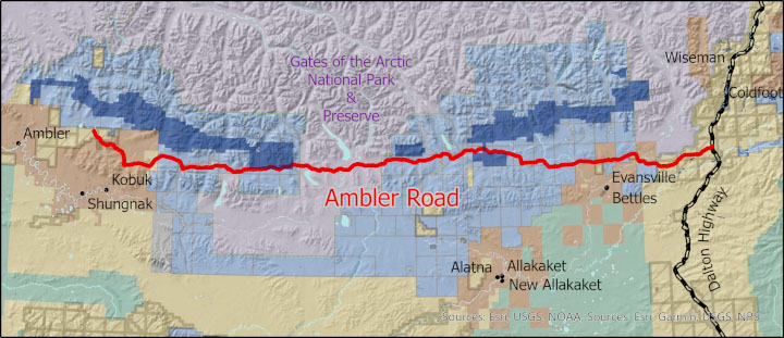
The Alaska Industrial Development and Export Authority (AIDEA) has proposed to construct a 211-mile private industrial access road from mile post 161 on the Dalton Highway to the Ambler Mining District. The road is intended to facilitate mine development and transportation of ore as part of the Ambler Access Project. The road would be controlled access for approved commercial uses only; no public access would be allowed.
The road alignment crosses lands owned and/or managed by federal, state, municipal, and private entities. Currently, AIDEA has secured right-of-way (ROW) authorizations to cross federal lands managed by the Bureau of Land Management (BLM) and National Park Service (NPS). Links to the BLM and NPS ROW permits, the Joint Record of Decision, and the Final Environmental Impact Statement can be accessed in the Federal Documents section below.
State Easement Application
On October 20, 2021, DMLW received an application for a private exclusive easement from AIDEA for those portions of the road on state-owned, DMLW-managed lands. The application requests a 450 ft wide easement over approximately 125 miles of the road alignment. A detailed description of the application request and proposed project details can be found in the Summary of Application for Private Easement document. A map of the road alignment with associated ancillary infrastructure can be found in Appendix A of this document.
Classification of Land
Prior to the disposal or transfer of state land or interest in state land, 11 AAC 55.040(i) requires that the land be classified. The Ambler Road alignment crosses state lands that are classified and unclassified: state lands within the Northwest Arctic Borough are classified under the Northwest Area Plan and Land Classification Order (LCO) NC-08-001, while lands east of the borough were previously unclassified. For the unclassified lands, DNR issued a Public Review Draft (PRD) of a Site Specific Plan (SSP) on January 31, 2022 for public review and comment. Prior to the April 1, 2022 comment deadline, DNR held two public meetings and received over 90 comments. The final SSP, adopted by the Commissioner of DNR on June 27, 2022, is posted below.
Notice
DMLW conducted concurrent 60-day public review and comment periods for AIDEA's application for an easement on state land, and DNR's draft Site Specific Plan, which closed on April 1, 2022.
State Easement Documents
Summary of Application for Private Exclusive Easement
Cover Letter from AIDEA to DMLW
Site Specific Land Use Plan
Federal Documents
Joint Record of Decision. July 2020. Prepared by U.S. Department of the Interior Bureau of Land Management and U.S. Army Corps of Engineers.
Right-of-Way Grant F-97112. January 5, 2021. Department of Interior Bureau of Land Management.
NPS Right-of-Way Permit No. RW GAAR-21-001. January 5, 2021. United States Department of Interior, National Park Service, Gates of the Arctic National Park and Preserve.
NPS Record of Decision. July 14, 2020. Decision by the Secretaries of the Interior and Transportation.
Bureau of Land Management documents may also be found at: https://eplanning.blm.gov/eplanning-ui/project/57323/570.
National Park Service documents may also be found at: https://parkplanning.nps.gov/documentsList.cfm?projectID=37092.