
Nenana-Totchaket Agricultural Project - Archive
NENANA-TOTCHAKET PROJECT FILES
Timeline
- Bridge open to public use
- Imagery data collected
- LiDAR and Imagery data delivered to DNR
- Final Finding and Decision for Land Offering
- NRCS soil survey of Phase 1 of about 33,000 acres
- Land Survey Contract Phase 1A
- Final Plat
- Cleared lot lines, NenTot Phase 1a
- Appraisals completed, Phase 1 a
- LiDAR / Picture validation of vegetation
- Weather Station Installation
- Invasive Species Studies
- Land Offering for Phase 1A
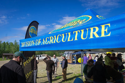
- Nenana Education day on June 10, 2022, Boat Launch
- Sealed Bid Auction begins June 1, 2022 10:00 AM
- Nenana-Totchaket Agricultural Project 2022 Land Sale Brochure (Auction #494)
- Sealed Bid for Auction #494 closes October 4, 20222 at 4:30 pm
- Opening of sealed bids for Auction #494 October 19, 2022 at 10:00 am
History
History
The Nenana-Totchaket (NenTot) region has been identified for agricultural development since the late 1970's. The Alaska Agricultural Action Council (AAAC) in 1982 reported "Nenana-Totchaket will play a particularly important role in the future of Alaskan agriculture" noting its access to the Parks Highway & Alaska Railroad; lower elevation than Delta; and not conflicting with other resource development.
The Commissioner of the Department of Natural Resources approved the Yukon Tanana Area Plan in 2014. This plan places 148,502 acres in the Kantishna Region, unit K-32, and Classifies/Designates them for Agricultural development.
A series of events and collaborative work with the City of Nenana and Nenana Native association has provided infrastructure that has propelled the development and made possible the phase 1a land offerings for 2022. The City of Nenana acquired an easement across the NenTot project and worked with oil exploration companies to leave infrastructure in-place, this includes 11 miles of gravel road & 3 bridges. The Nenana Native Association received a Federal grant in 2018 and completed a bridge across the Nenana River allowing access to the project area. It is this collaborative effort between different agencies that has made this possible.
Bridge construction was completed in spring 2020, and road access to the NenTot project area was open in July 2020. Following this, public hearings and area development plans were developed with the use of LiDAR, Imagery, & Infrared data collected in 2020. A corporative agreement with USDA-NRCS was established to collect soil and ecological site information for the initial planned development areas. Soil data collection began in 2020 and continued through the summer of 2021. This data is anticipated to be available for review in the spring of 2022 to support landowners in developing their State Farm Conservation plans. Survey of the phase 1a township was completed in 2021 and brushing of the lot lines will be completed early winter 2022. Land appraisals are anticipated to be completed and land sales for phase 1a will follow when these are complete.
The Division of Agriculture in cooperation with the City of Nenana is planning another Agricultural Education Day near the Totchaket Bridge crossing the Nenana River in June 2022. This will be an open house event to showcase the Phase 1a parcels and provide educational and outreach opportunities for our partners to share their agricultural knowledge and research with the public.
Agriculture Education
Education Resources
Workshops: Nenana Agriculture Education Day June 10 & 11, 2022 (Coming Soon)
The University of Alaska Fairbanks, Institute of Agriculture, Natural Resources and Extension
UAF Cooperative Extension Service
UAF Cooperative Extension Publications Catalog
Alaska Plant Materials Center - Horticulture Program
Alaska Plant Materials Center - Seed Foundation
Alaska Plant Materials Center - Soil Conservation
Fairbanks Soil and Water District
USDA: Alaska Natural Resources Conservation Service
Agricultural Revolving Loan Fund
Peonies - Alaska Master Gardeners
Peonies - Division of Ag Program
Division of Ag Land Program Information / State Farm Conservation Plans / Ag Land Restrictions
News
KUAC Radio Program with Tim Ellis: Agriculture Event to Promote Opportunities in Area Near Nenana Made Accessible by Bridge.
Erik "Moe" Johnson appears as a guest to speak about the Nen Tot project and Nenana Ag Day.
Alaska Public Media TV Special: State hopes upcoming agricultural land sale near Nenana will bear fruit.
Alaska Public Media TV Show Insight: Alaska is leading the nation in new farm growth. Is it enough to address food security concerns?
Facebook Live 4-29-21, Nenana Totchaket Ag Land Project Update: Erik Johnson and Damon Hampel discuss the project and take comments and questions from the public.
Facebook Live 6-10-21, Nen Tot Ag Day: Director Schade live from Nenana, invites people to come down for Agriculture Day, and describes the Nen Tot project and its goals.
Associated Press Article on 5-18-21: Alaska Governor seeks $5 million for large farming project.
KNBA Article on 7-29-2020: New Bridge Opens Access to Land and Economic Opportunity.
Frontiersman Newspaper Article on 2-22-21: With Bridge built, new state agriculture project could open 180,000 acres west of Nenana.